
File:Lage der Berliner Flughäfen-T.svg

Size of this PNG preview of this SVG file: ༧༤༤ × ༦༠༠ pixels. Other resolutions: ༢༩༨ × ༢༤༠ pixels | ༥༩༥ × ༤༨༠ pixels | ༩༥༣ × ༧༦༨ pixels | ༡,༢༧༠ × ༡,༠༢༤ pixels | ༢,༥༤༠ × ༢,༠༤༨ pixels.
ཐོག་མའི་ཡིག་ཆ། (SVG file, nominally ༨༠༠ × ༦༤༥ pixels, file size: ༣༨༧ KB)
| Description |
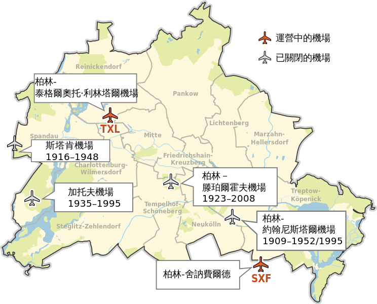
English: Map of Berlin with the Berlin airports(tra-chinese). |
| Date | |
| Source | File:Lage der Berliner Flughäfen.svg |
| Author | Ai6z83xl3g |
| Permission (Reusing this file) |
I, the copyright holder of this work, hereby publish it under the following license: This file is licensed under the Creative Commons Attribution-Share Alike 2.5 Generic license.
|
| Other versions | Lage der Berliner Flughäfen.svg |
ཡིག་ཆའི་ལོ་རྒྱུས།
ཟླ་ཚེས་/དུས་ཚོད་གནུན་ཏེ་རྩོམ་ཡིག་ལ་ལྟ་བ།
| ཚེས་གྲངས། / དུས་ཚོད། | བསྡུས་དོན། | ཚད། | སྤྱོད་མི། | བསམ་ཚུལ། | |
|---|---|---|---|---|---|
| ད་ལྟ། | ༠༢:༥༥, ༣༠ ཟླ་དྲུག་པ། ༢༠༡༡ | | ༨༠༠ × ༦༤༥ (༣༨༧ KB) | Aizag | {{Information |Description ={{en|1=Map of Berlin with the Berlin airports(tra-chinese).}} |Source ={{own}} |Author =Ai6z83xl3g |Date =2011.6.30 |Permission ={{self|Cc-by-sa-2.5}} |other_versions =Lage d |
ཡིག་ཆ་བེད་སྤྱོད་ཁུལ།
pagelinks འདི་ལ་སྦྲེལ་ཡོད།
Global file usage
The following other wikis use this file:
- Usage on zh.wikipedia.org