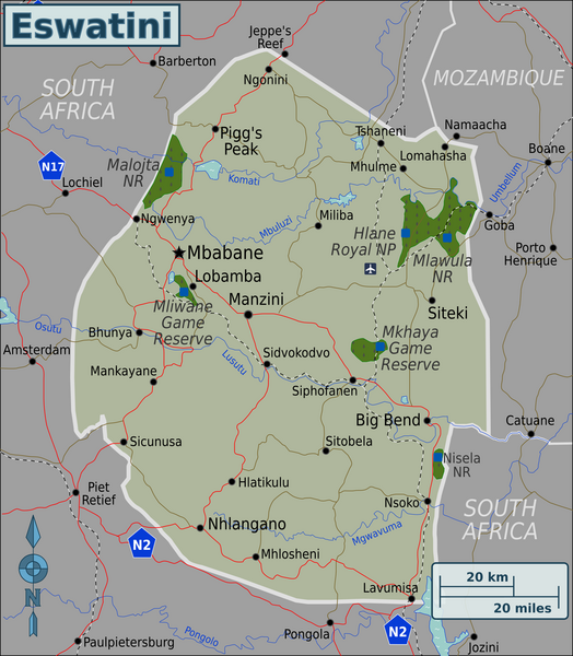
File:Eswatini Regions map.png

Size of this preview: ༥༢༤ × ༦༠༠ pixels. Other resolutions: ༢༡༠ × ༢༤༠ pixels | ༤༡༩ × ༤༨༠ pixels | ༦༧༡ × ༧༦༨ pixels | ༨༩༥ × ༡,༠༢༤ pixels | ༢,༠༠༠ × ༢,༢༨༩ pixels.
ཐོག་མའི་ཡིག་ཆ། (༢,༠༠༠ × ༢,༢༨༩ བརྙན་རྒྱུ།, ཡིག་ཆ་ཆེ་ཆུང།: ༡༣.༡༢ MB, རྣམ་གཞག།: image/png)
ཡིག་ཆའི་ལོ་རྒྱུས།
ཟླ་ཚེས་/དུས་ཚོད་གནུན་ཏེ་རྩོམ་ཡིག་ལ་ལྟ་བ།
| ཚེས་གྲངས། / དུས་ཚོད། | བསྡུས་དོན། | ཚད། | སྤྱོད་མི། | བསམ་ཚུལ། | |
|---|---|---|---|---|---|
| ད་ལྟ། | ༠༥:༣༤, ༩ ཟླ་བརྒྱད་པ། ༢༠༢༠ |  | ༢,༠༠༠ × ༢,༢༨༩ (༡༣.༡༢ MB) | Bestoernesto | Moved the International Airport to the right place |
| ༡༩:༡༩, ༨ ཟླ་གསུམ། ༢༠༡༩ |  | ༢,༠༠༠ × ༢,༢༨༩ (༡.༠༨ MB) | Shaundd | Swaziland > Eswatini, changes to improve readability, reframe map so more focus on Eswatini | |
| ༠༡:༡༠, ༡༩ ཟླ་བཅུ་གཉིས་པ། ༢༠༡༢ |  | ༢,༤༨༦ × ༢,༩༤༡ (༡.༥༧ MB) | OgreBot | (BOT): Reverting to most recent version before archival | |
| ༠༡:༡༠, ༡༩ ཟླ་བཅུ་གཉིས་པ། ༢༠༡༢ |  | ༢,༤༨༦ × ༢,༩༤༡ (༡.༥༧ MB) | OgreBot | (BOT): Uploading old version of file from wts.wikivoyage; originally uploaded on 2010-03-08 03:40:17 by (WT-shared) Burmesedays | |
| ༠༡:༡༠, ༡༩ ཟླ་བཅུ་གཉིས་པ། ༢༠༡༢ |  | ༢,༤༨༦ × ༢,༩༤༡ (༡.༦༡ MB) | OgreBot | (BOT): Uploading old version of file from wts.wikivoyage; originally uploaded on 2010-03-07 13:25:31 by (WT-shared) Burmesedays | |
| ༠༡:༠༩, ༡༩ ཟླ་བཅུ་གཉིས་པ། ༢༠༡༢ |  | ༢,༤༨༦ × ༢,༩༤༡ (༡.༥༩ MB) | OgreBot | (BOT): Uploading old version of file from wts.wikivoyage; originally uploaded on 2010-03-07 09:32:32 by (WT-shared) Burmesedays | |
| ༠༢:༥༧, ༡༨ ཟླ་བཅུ་གཅིག་པ། ༢༠༡༢ |  | ༢,༤༨༦ × ༢,༩༤༡ (༡.༥༧ MB) | MGA73bot2 | {{BotMoveToCommons|wts.oldwikivoyage|year={{subst:CURRENTYEAR}}|month={{subst:CURRENTMONTHNAME}}|day={{subst:CURRENTDAY}}}} == {{int:filedesc}} == {{Information |description=Map of Swaziland with regions colour coded. Map of Swaziland, Swaziland * Map ... |
ཡིག་ཆ་བེད་སྤྱོད་ཁུལ།
pagelinks འདི་ལ་སྦྲེལ་ཡོད།
Global file usage
The following other wikis use this file:
- Usage on ace.wikipedia.org
- Usage on af.wikipedia.org
- Usage on ang.wikipedia.org
- Usage on ary.wikipedia.org
- Usage on ast.wikipedia.org
- Usage on avk.wikipedia.org
- Usage on ay.wikipedia.org
- Usage on azb.wikipedia.org
- Usage on az.wikipedia.org
- Usage on ban.wikipedia.org
- Usage on bat-smg.wikipedia.org
- Usage on ba.wikipedia.org
- Usage on bcl.wikipedia.org
- Usage on bh.wikipedia.org
- Usage on bi.wikipedia.org
- Usage on bjn.wikipedia.org
- Usage on bm.wikipedia.org
- Usage on bpy.wikipedia.org
- Usage on br.wikipedia.org
- Usage on bs.wikipedia.org
- Usage on bxr.wikipedia.org
- Usage on cbk-zam.wikipedia.org
- Usage on cdo.wikipedia.org
- Usage on ceb.wikipedia.org
- Usage on ce.wikipedia.org
- Usage on ckb.wikipedia.org
- Usage on crh.wikipedia.org
- Usage on cs.wikipedia.org
- Usage on cy.wikipedia.org
- Usage on da.wikipedia.org
- Usage on de.wikivoyage.org
- Usage on diq.wikipedia.org
- Usage on dty.wikipedia.org
- Usage on ee.wikipedia.org
- Usage on en.wikivoyage.org
- Usage on eo.wikipedia.org
- Usage on fa.wikipedia.org
- Usage on fiu-vro.wikipedia.org
- Usage on fr.wikivoyage.org
- Usage on fy.wikipedia.org
- Usage on ga.wikipedia.org
- Usage on gd.wikipedia.org
- Usage on gl.wikipedia.org
- Usage on he.wikivoyage.org
- Usage on hi.wikipedia.org
- Usage on hr.wikipedia.org
- Usage on incubator.wikimedia.org
View more global usage of this file.
