
File:Asie.svg

Size of this PNG preview of this SVG file: ༧༨༨ × ༦༠༠ pixels. Other resolutions: ༣༡༦ × ༢༤༠ pixels | ༦༣༡ × ༤༨༠ pixels | ༡,༠༠༩ × ༧༦༨ pixels | ༡,༢༨༠ × ༩༧༤ pixels | ༢,༥༦༠ × ༡,༩༤༨ pixels | ༡,༡༠༠ × ༨༣༧ pixels.
ཐོག་མའི་ཡིག་ཆ། (SVG file, nominally ༡,༡༠༠ × ༨༣༧ pixels, file size: ༥༦༧ KB)
| Description |
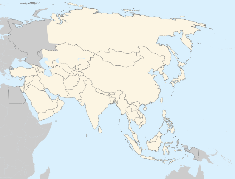
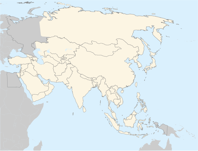
Français : Carte politique de l'Asie
English: Asia political map. The continental boundary to Europe follows the mainstream convention along the Urals, the Ural River, and the crest of the Greater Caucasus.
Português: Mapa politico da Ásia. |
||
| Date | |||
| Source | http://en.wikipedia.org/wiki/Image:BlankMap-World5.svg | ||
| Author | historicair 20:31, 20 November 2006 (UTC) | ||
| Permission (Reusing this file) |
|
||
| Other versions |
Derivative works of this file: |
ཡིག་ཆའི་ལོ་རྒྱུས།
ཟླ་ཚེས་/དུས་ཚོད་གནུན་ཏེ་རྩོམ་ཡིག་ལ་ལྟ་བ།
| ཚེས་གྲངས། / དུས་ཚོད། | བསྡུས་དོན། | ཚད། | སྤྱོད་མི། | བསམ་ཚུལ། | |
|---|---|---|---|---|---|
| ད་ལྟ། | ༡༨:༢༧, ༤ ཟླ་དགུ་བ། ༢༠༢༢ | | ༡,༡༠༠ × ༨༣༧ (༥༦༧ KB) | Рагин1987 | Correction |
| ༢༠:༠༧, ༣༠ ཟླ་བརྒྱད་པ། ༢༠༢༢ |  | ༢,༥༦༠ × ༡,༩༤༨ (༩༣༥ KB) | Рагин1987 | More correct visualization of the dividing line on the territory of the Caucasus Range | |
| ༠༢:༣༧, ༡༣ ཟླ་བཞི་བ། ༢༠༡༡ |  | ༡,༡༠༠ × ༨༣༧ (༥༢༢ KB) | Gerge | Reverted to version as of 06:06, 12 April 2011 | |
| ༢༣:༡༡, ༡༢ ཟླ་བཞི་བ། ༢༠༡༡ |  | ༡,༡༠༠ × ༨༣༧ (༥༢༢ KB) | Green, White and Gold | Reverted to Dbachmann's version as of 06:52, 11 April 2011 | |
| ༠༦:༠༦, ༡༢ ཟླ་བཞི་བ། ༢༠༡༡ |  | ༡,༡༠༠ × ༨༣༧ (༥༢༢ KB) | Sigismun | Reverted to version as of 00:55, 12 April 2011 | |
| ༠༡:༠༠, ༡༢ ཟླ་བཞི་བ། ༢༠༡༡ |  | ༡,༡༠༠ × ༨༣༧ (༥༢༢ KB) | Green, White and Gold | Reverted to Dbachmann's version as of 06:52, 11 April 2011 | |
| ༠༠:༥༥, ༡༢ ཟླ་བཞི་བ། ༢༠༡༡ |  | ༡,༡༠༠ × ༨༣༧ (༥༢༢ KB) | Green, White and Gold | Reverted to Dbachmann's version as of 06:52, 11 April 2011 | |
| ༡༤:༡༦, ༡༡ ཟླ་བཞི་བ། ༢༠༡༡ |  | ༧༨༨ × ༦༠༠ (༡༩༧ KB) | ComtesseDeMingrelie | Reverted to version as of 14:45, 5 April 2011 | |
| ༠༦:༥༢, ༡༡ ཟླ་བཞི་བ། ༢༠༡༡ |  | ༡,༡༠༠ × ༨༣༧ (༥༢༢ KB) | Dbachmann | Reverted to version as of 20:44, 4 April 2011 | |
| ༡༤:༤༥, ༥ ཟླ་བཞི་བ། ༢༠༡༡ |  | ༧༨༨ × ༦༠༠ (༡༩༧ KB) | ComtesseDeMingrelie | Reverted to version as of 01:05, 5 April 2011 |
ཡིག་ཆ་བེད་སྤྱོད་ཁུལ།
There are no pages that use this file.
Global file usage
The following other wikis use this file:
- Usage on ar.wikipedia.org
- Usage on az.wikipedia.org
- Usage on bg.wikipedia.org
- Usage on bh.wikipedia.org
- Usage on ca.wikipedia.org
- Usage on cs.wikipedia.org
- Usage on el.wikipedia.org
- Usage on en.wikipedia.org
- Usage on fa.wikipedia.org
- Usage on gl.wikipedia.org
- Usage on hi.wikipedia.org
- Usage on hr.wikipedia.org
- Usage on incubator.wikimedia.org
- Usage on it.wikipedia.org
View more global usage of this file.