
File:Munnar Top station.jpg

Size of this preview: ༨༠༠ × ༤༩༤ pixels. Other resolutions: ༣༢༠ × ༡༩༧ pixels | ༦༤༠ × ༣༩༥ pixels | ༡,༠༢༤ × ༦༣༢ pixels | ༡,༢༤༦ × ༧༦༩ pixels.
ཐོག་མའི་ཡིག་ཆ། (༡,༢༤༦ × ༧༦༩ བརྙན་རྒྱུ།, ཡིག་ཆ་ཆེ་ཆུང།: ༩༠༥ KB, རྣམ་གཞག།: image/jpeg)
བསྡུས་དོན།
| Description |
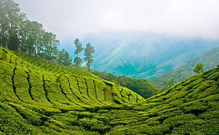
English: Top station, 41 km (1hr) from Munnar is aptly named, as it is home to some of the highest tea plantations in India. It lies on the state border between Kerala and Tamilnadu and commands a panoramic view of rolling green hills. |
||
| Date | |||
| Source | Top Station - Munnar | ||
| Author | Bimal K C from Cochin, India | ||
| Permission (Reusing this file) |
This file is licensed under the Creative Commons Attribution 2.0 Generic license.
|
|
ཡིག་ཆའི་ལོ་རྒྱུས།
ཟླ་ཚེས་/དུས་ཚོད་གནུན་ཏེ་རྩོམ་ཡིག་ལ་ལྟ་བ།
| ཚེས་གྲངས། / དུས་ཚོད། | བསྡུས་དོན། | ཚད། | སྤྱོད་མི། | བསམ་ཚུལ། | |
|---|---|---|---|---|---|
| ད་ལྟ། | ༡༣:༠༥, ༦ ཟླ་བཞི་བ། ༢༠༡༡ | | ༡,༢༤༦ × ༧༦༩ (༩༠༥ KB) | Ras67 | cropped |
| ༡༢:༠༣, ༡༢ ཟླ་བརྒྱད་པ། ༢༠༠༨ |  | ༡,༢༨༠ × ༨༠༣ (༩༥༢ KB) | Challiyan | {{Information |Description= Top station, 41 km (1hr) from Munnar is aptly named, as it is home to some of the highest tea plantations in India. It lies on the state border between Kerala and Tamilnadu and commands a panoramic view of rolling green hills. |
ཡིག་ཆ་བེད་སྤྱོད་ཁུལ།
pagelinks འདི་ལ་སྦྲེལ་ཡོད།
Global file usage
The following other wikis use this file:
- Usage on cs.wikipedia.org
- Usage on de.wikipedia.org
- Usage on en.wikipedia.org
- Usage on en.wikivoyage.org
- Usage on es.wikipedia.org
- Usage on fr.wikipedia.org
- Usage on gu.wikipedia.org
- Usage on id.wikipedia.org
- Usage on incubator.wikimedia.org
- Usage on kn.wikipedia.org
- Usage on ml.wikipedia.org
- കേരളം
- മൂന്നാർ
- വിക്കിപീഡിയ:തിരഞ്ഞെടുക്കാവുന്ന ചിത്രങ്ങൾ/നിലവറ 19
- വിക്കിപീഡിയ:തിരഞ്ഞെടുത്ത ചിത്രങ്ങൾ/മേയ് 2016
- വിക്കിപീഡിയ:തിരഞ്ഞെടുത്ത ചിത്രങ്ങൾ/08-05-2016
- വിക്കിപീഡിയ:തിരഞ്ഞെടുത്ത ചിത്രങ്ങൾ/09-05-2016
- വിക്കിപീഡിയ:തിരഞ്ഞെടുത്ത ചിത്രങ്ങൾ/10-05-2016
- വിക്കിപീഡിയ:തിരഞ്ഞെടുത്ത ചിത്രങ്ങൾ/11-05-2016
- വിക്കിപീഡിയ:തിരഞ്ഞെടുത്ത ചിത്രങ്ങൾ/12-05-2016
- വിക്കിപീഡിയ:തിരഞ്ഞെടുത്ത ചിത്രങ്ങൾ/13-05-2016
- വിക്കിപീഡിയ:തിരഞ്ഞെടുത്ത ചിത്രങ്ങൾ/14-05-2016
- Usage on nl.wikipedia.org
- Usage on no.wiktionary.org
- Usage on pl.wikipedia.org
- Usage on ru.wikipedia.org
- Usage on sa.wikipedia.org
- Usage on sv.wikipedia.org
- Usage on ta.wikipedia.org
- Usage on te.wikipedia.org
- Usage on ur.wikipedia.org
- Usage on war.wikipedia.org