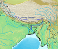
File:Brahmaputrarivermap.png
Brahmaputrarivermap.png (༤༤༩ × ༣༨༡ བརྙན་རྒྱུ།, ཡིག་ཆ་ཆེ་ཆུང།: ༣༠༨ KB, རྣམ་གཞག།: image/png)
ཡིག་ཆའི་ལོ་རྒྱུས།
ཟླ་ཚེས་/དུས་ཚོད་གནུན་ཏེ་རྩོམ་ཡིག་ལ་ལྟ་བ།
| ཚེས་གྲངས། / དུས་ཚོད། | བསྡུས་དོན། | ཚད། | སྤྱོད་མི། | བསམ་ཚུལ། | |
|---|---|---|---|---|---|
| ད་ལྟ། | ༡༢:༠༦, ༡༢ ཟླ་གསུམ། ༢༠༡༩ |  | ༤༤༩ × ༣༨༡ (༣༠༨ KB) | Maphobbyist | Reverted to version as of 10:19, 21 February 2019 (UTC) |
| ༡༢:༡༨, ༢༢ ཟླ་གཉིས་པ། ༢༠༡༩ |  | ༤༤༩ × ༣༨༡ (༡༦༡ KB) | FakeDJT | Reverted to version as of 08:24, 13 December 2018 (UTC) | |
| ༡༠:༡༩, ༢༡ ཟླ་གཉིས་པ། ༢༠༡༩ |  | ༤༤༩ × ༣༨༡ (༣༠༨ KB) | Maphobbyist | Reverted to version as of 19:02, 26 September 2007 (UTC) | |
| ༠༨:༢༦, ༡༣ ཟླ་བཅུ་གཉིས་པ། ༢༠༡༨ |  | ༤༤༩ × ༣༨༡ (༡༦༡ KB) | FakeDJT | Reverted to version as of 08:24, 13 December 2018 (UTC) | |
| ༠༨:༢༥, ༡༣ ཟླ་བཅུ་གཉིས་པ། ༢༠༡༨ |  | ༤༤༩ × ༣༨༡ (༣༠༨ KB) | FakeDJT | Reverted to version as of 19:02, 26 September 2007 (UTC) | |
| ༠༨:༢༤, ༡༣ ཟླ་བཅུ་གཉིས་པ། ༢༠༡༨ |  | ༤༤༩ × ༣༨༡ (༡༦༡ KB) | FakeDJT | Fix | |
| ༡༩:༠༢, ༢༦ ཟླ་དགུ་བ། ༢༠༠༧ |  | ༤༤༩ × ༣༨༡ (༣༠༨ KB) | Kmusser | {{Information |Description=Map of the Brahmaputra/Yarlung Tsangpo river. |Source=Self-made, based on the [http://www2.demis.nl/mapserver/mapper.asp DEMIS map server]. |Date=September 26, 2007 |
ཡིག་ཆ་བེད་སྤྱོད་ཁུལ།
pagelinks འདི་ལ་སྦྲེལ་ཡོད།
Global file usage
The following other wikis use this file:
- Usage on af.wikipedia.org
- Usage on be.wikipedia.org
- Usage on bg.wikipedia.org
- Usage on bn.wikipedia.org
- Usage on ca.wikipedia.org
- Usage on cy.wikipedia.org
- Usage on de.wikipedia.org
- Usage on en.wikipedia.org
- Usage on es.wikipedia.org
- Usage on gl.wikipedia.org
- Usage on hi.wikipedia.org
- Usage on ja.wikipedia.org
- Usage on jv.wikipedia.org
- Usage on kn.wikipedia.org
- Usage on ko.wikipedia.org
- Usage on nl.wikipedia.org
- Usage on nn.wikipedia.org
- Usage on no.wikipedia.org
- Usage on oc.wikipedia.org
- Usage on pl.wikipedia.org
- Usage on pnb.wikipedia.org
- Usage on ro.wikipedia.org
- Usage on sk.wikipedia.org
- Usage on sv.wikipedia.org
- Usage on sw.wikipedia.org
- Usage on zh.wikipedia.org

