
File:Terminalplan TXL DE.svg

Size of this PNG preview of this SVG file: ༨༠༠ × ༦༠༠ pixels. Other resolutions: ༣༢༠ × ༢༤༠ pixels | ༦༤༠ × ༤༨༠ pixels | ༡,༠༢༤ × ༧༦༨ pixels | ༡,༢༨༠ × ༩༦༠ pixels | ༢,༥༦༠ × ༡,༩༢༠ pixels.
ཐོག་མའི་ཡིག་ཆ། (SVG file, nominally ༡,༠༢༤ × ༧༦༨ pixels, file size: ༣༧༩ KB)
བསྡུས་དོན།
| Description |
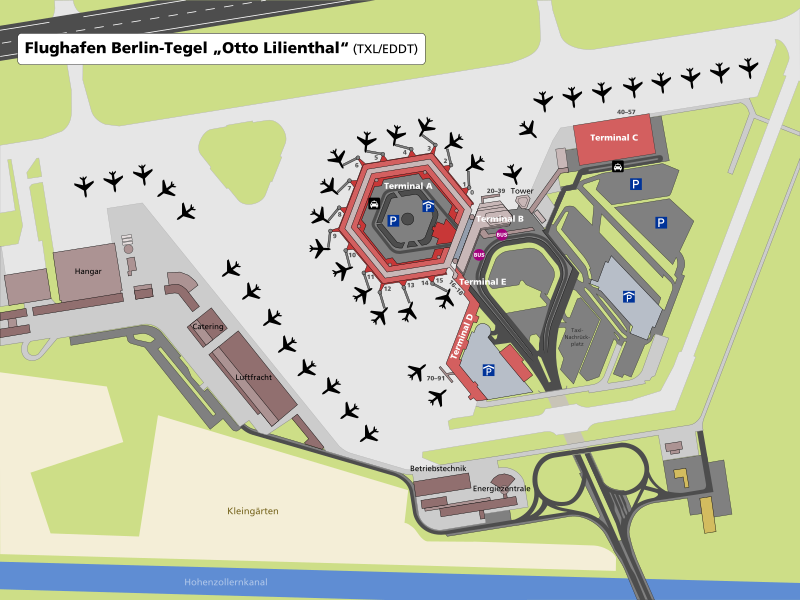
 Deutsch: Übersichtskarte der Terminal-Gebäude des Flughafens Berlin-Tegel. Der tatsächliche Bauzustand unterscheidet sich deutlich von den ursprünglichen Planungen aus den 1960er Jahren, siehe: TXL - Ursprüngliche Planung Endausbau
|
| Date | |
| Source | Own work |
| Author | Michael F. Mehnert |
| Other versions | File:Airport map TXL EN.svg (english version) |
Darstellung basiert auf der Rasterkarte des Landes Berlin 1:5000, openstreetmap.org, Luftbildern und eigenen Fotos (u. a. TXL 2007-09-07 TerminalC 2.jpg).
| Camera location | | View this and other nearby images on: OpenStreetMap |
|---|
གན་རྒྱ་ནང་ཞུགས་པ།
I, the copyright holder of this work, hereby publish it under the following licenses:

|
Permission is granted to copy, distribute and/or modify this document under the terms of the GNU Free Documentation License, Version 1.2 or any later version published by the Free Software Foundation; with no Invariant Sections, no Front-Cover Texts, and no Back-Cover Texts. A copy of the license is included in the section entitled GNU Free Documentation License. |
This file is licensed under the Creative Commons Attribution-Share Alike 3.0 Unported, 2.5 Generic, 2.0 Generic and 1.0 Generic license.
- You are free:
- to share – to copy, distribute and transmit the work
- to remix – to adapt the work
- Under the following conditions:
- attribution – You must give appropriate credit, provide a link to the license, and indicate if changes were made. You may do so in any reasonable manner, but not in any way that suggests the licensor endorses you or your use.
- share alike – If you remix, transform, or build upon the material, you must distribute your contributions under the same or compatible license as the original.
You may select the license of your choice.
ཡིག་ཆའི་ལོ་རྒྱུས།
ཟླ་ཚེས་/དུས་ཚོད་གནུན་ཏེ་རྩོམ་ཡིག་ལ་ལྟ་བ།
| ཚེས་གྲངས། / དུས་ཚོད། | བསྡུས་དོན། | ཚད། | སྤྱོད་མི། | བསམ་ཚུལ། | |
|---|---|---|---|---|---|
| ད་ལྟ། | ༡༦:༠༡, ༨ ཟླ་ལྔ་བ། ༢༠༠༩ | | ༡,༠༢༤ × ༧༦༨ (༣༧༩ KB) | Nervousenergy | Removed unused xml. |
| ༡༣:༡༨, ༨ ཟླ་ལྔ་བ། ༢༠༠༩ |  | ༡,༠༢༤ × ༧༦༨ (༤༨༧ KB) | Nervousenergy | {{Information |Description={{en|1=Map of the terminal area of Berlin-Tegel airport labeled in German.}} {{de|1=Übersichtskarte der Terminal-Gebäude des Flughafens Berlin-Tegel.}} |Source=Own work. |A |
ཡིག་ཆ་བེད་སྤྱོད་ཁུལ།
pagelinks འདི་ལ་སྦྲེལ་ཡོད།
Global file usage
The following other wikis use this file:
- Usage on bg.wikipedia.org
- Usage on de.wikipedia.org
- Usage on zh.wikipedia.org