
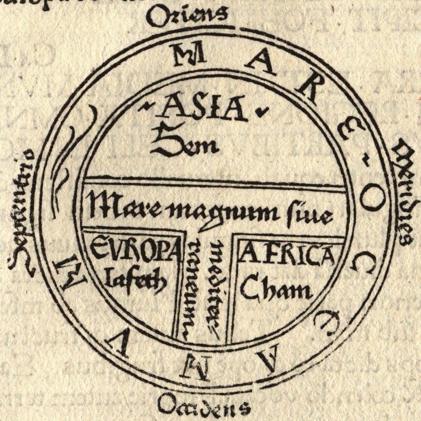
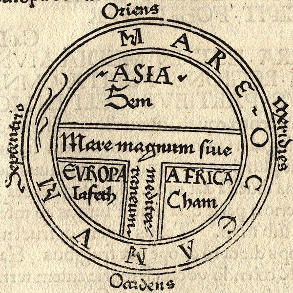
File:T and O map Guntherus Ziner 1472.jpg
Size of this preview: ༦༠༠ × ༦༠༠ pixels. Other resolutions: ༢༤༠ × ༢༤༠ pixels | ༤༨༠ × ༤༨༠ pixels | ༨༦༤ × ༨༦༤ pixels.
ཐོག་མའི་ཡིག་ཆ། (༨༦༤ × ༨༦༤ བརྙན་རྒྱུ།, ཡིག་ཆ་ཆེ་ཆུང།: ༢༧༩ KB, རྣམ་གཞག།: image/jpeg)
བསྡུས་དོན།
| Artist |
Isidore of Seville |
| Description |
|
| Source/Photographer |

གན་རྒྱ་ནང་ཞུགས་པ།
|
This is a faithful photographic reproduction of a two-dimensional, public domain work of art. The work of art itself is in the public domain for the following reason:
The official position taken by the Wikimedia Foundation is that "faithful reproductions of two-dimensional public domain works of art are public domain".
This photographic reproduction is therefore also considered to be in the public domain in the United States. In other jurisdictions, re-use of this content may be restricted; see Reuse of PD-Art photographs for details. | ||||
ཡིག་ཆའི་ལོ་རྒྱུས།
ཟླ་ཚེས་/དུས་ཚོད་གནུན་ཏེ་རྩོམ་ཡིག་ལ་ལྟ་བ།
| ཚེས་གྲངས། / དུས་ཚོད། | བསྡུས་དོན། | ཚད། | སྤྱོད་མི། | བསམ་ཚུལ། | |
|---|---|---|---|---|---|
| ད་ལྟ། | ༢༢:༤༣, ༡༨ ཟླ་བརྒྱད་པ། ༢༠༠༦ | | ༨༦༤ × ༨༦༤ (༢༧༩ KB) | Ma xyz | Reverted to earlier revision |
| ༢༢:༤༢, ༡༨ ཟླ་བརྒྱད་པ། ༢༠༠༦ |  | ༢༢༤ × ༢༣༨ (༡༨ KB) | Ma xyz | Reverted to earlier revision | |
| ༠༦:༣༤, ༡༡ ཟླ་བརྒྱད་པ། ༢༠༠༦ |  | ༨༦༤ × ༨༦༤ (༢༧༩ KB) | Leinad-Z~commonswiki | Larger version, cropped from Image:T-O map 1472.jpg | |
| ༡༠:༢༥, ༢༤ ཟླ་ལྔ་བ། ༢༠༠༥ |  | ༢༢༤ × ༢༣༨ (༡༨ KB) | Dbachmann | detail of Image:Etymologiae Guntherus Ziner 1472.jpg {{PD-art}} |
ཡིག་ཆ་བེད་སྤྱོད་ཁུལ།
pagelinks འདི་ལ་སྦྲེལ་ཡོད།
Global file usage
The following other wikis use this file:
- Usage on ar.wikipedia.org
- Usage on arz.wikipedia.org
- Usage on ast.wikipedia.org
- Usage on be.wikipedia.org
- Usage on bg.wikipedia.org
- Usage on bn.wikipedia.org
- Usage on br.wikipedia.org
- Usage on bs.wikipedia.org
- Usage on ca.wikipedia.org
- Usage on cs.wikipedia.org
- Usage on cv.wikipedia.org
- Usage on da.wikipedia.org
- Usage on de.wikipedia.org
- Usage on de.wikibooks.org
- Usage on el.wikipedia.org
- Usage on en.wikipedia.org
- Christendom
- Cartography
- Europe
- Japheth
- Shem
- Semitic people
- Generations of Noah
- Old World
- T and O map
- Japhetites
- User:Nurg/Continent
- Racial antisemitism
- Talk:Eurocentrism
- Continent
- Hamites
- Fantasy cartography
- Günther Zainer
- God's Philosophers
- Cartographic propaganda
- Wikipedia:Reference desk/Archives/Humanities/2016 November 20
- User:Falcaorib
View more global usage of this file.