
File:Solomon Islands-CIA WFB Map.png
No higher resolution available.
Solomon_Islands-CIA_WFB_Map.png (༣༢༩ × ༣༥༥ བརྙན་རྒྱུ།, ཡིག་ཆ་ཆེ་ཆུང།: ༦ KB, རྣམ་གཞག།: image/png)
གན་རྒྱ་ནང་ཞུགས་པ།
| Description |
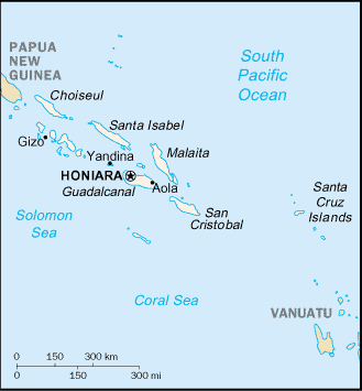
English: Map of Solomon Islands, showing major towns. |
|||
| Date | ||||
| Source | CIA, The World Factbook, 2004 (internet version) | |||
| Author | CIA | |||
| Permission (Reusing this file) |
|
|||
| Other versions |
|


ཡིག་ཆའི་ལོ་རྒྱུས།
ཟླ་ཚེས་/དུས་ཚོད་གནུན་ཏེ་རྩོམ་ཡིག་ལ་ལྟ་བ།
| ཚེས་གྲངས། / དུས་ཚོད། | བསྡུས་དོན། | ཚད། | སྤྱོད་མི། | བསམ་ཚུལ། | |
|---|---|---|---|---|---|
| ད་ལྟ། | ༠༩:༡༧, ༢༧ ཟླ་གསུམ། ༢༠༠༥ | | ༣༢༩ × ༣༥༥ (༦ KB) | Wolfman~commonswiki | {{CIA-map}} |
ཡིག་ཆ་བེད་སྤྱོད་ཁུལ།
pagelinks འདི་ལ་སྦྲེལ་ཡོད།
Global file usage
The following other wikis use this file:
- Usage on af.wikipedia.org
- Usage on ar.wikipedia.org
- Usage on ast.wikipedia.org
- Usage on az.wikipedia.org
- Usage on bg.wikipedia.org
- Usage on br.wikipedia.org
- Usage on ca.wikipedia.org
- Usage on ceb.wikipedia.org
- Usage on de.wikipedia.org
- Usage on de.wikinews.org
- Usage on en.wikipedia.org
- Usage on en.wikisource.org
- Usage on eo.wikipedia.org
- Usage on es.wikipedia.org
- Usage on ext.wikipedia.org
- Usage on fa.wikipedia.org
- Usage on fi.wikipedia.org
- Usage on fr.wikipedia.org
- Usage on fr.wiktionary.org
- Usage on fy.wikipedia.org
- Usage on gd.wikipedia.org
- Usage on gl.wikipedia.org
- Usage on gom.wikipedia.org
- Usage on he.wikipedia.org
- Usage on incubator.wikimedia.org
- Usage on io.wikipedia.org
- Usage on is.wikipedia.org
- Usage on ka.wikipedia.org
- Usage on lb.wikipedia.org
- Usage on ml.wikipedia.org
- Usage on mr.wikipedia.org
- Usage on nl.wikipedia.org
- Usage on nn.wikipedia.org
- Usage on oc.wikipedia.org
- Usage on pl.wikipedia.org
View more global usage of this file.