
File:Provence topographic map-fr.svg

Size of this PNG preview of this SVG file: ༤༨༤ × ༤༤༠ pixels. Other resolutions: ༢༦༤ × ༢༤༠ pixels | ༥༢༨ × ༤༨༠ pixels | ༨༤༥ × ༧༦༨ pixels | ༡,༡༢༦ × ༡,༠༢༤ pixels | ༢,༢༥༣ × ༢,༠༤༨ pixels.
ཐོག་མའི་ཡིག་ཆ། (SVG file, nominally ༤༨༤ × ༤༤༠ pixels, file size: ༡.༥༥ MB)
| Description |
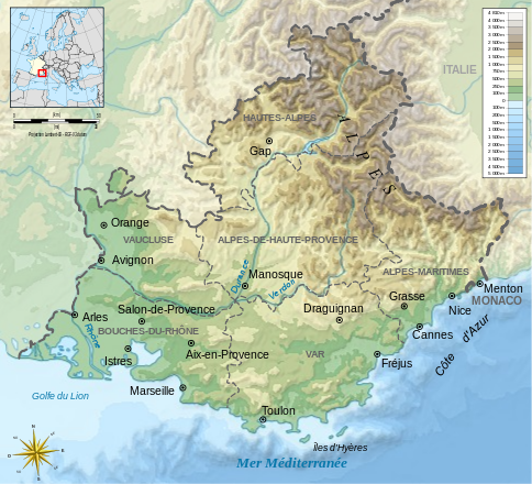
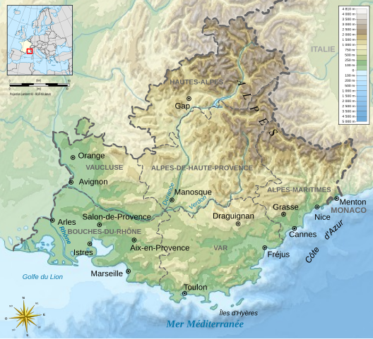
Français : Carte topographique de Provence-Alpes-Côte d'Azur Deutsch: Topographische Karte zum Provence-Alpes-Côte d'Azur English: Topographic map of Provence-Alpes-Côte d'Azur Español: Mapa topográfico de Provenza-Alpes-Costa Azul Italiano: Carta topografica de Provenza-Alpi-Costa Azzurra 日本語: 表示したプロヴァンス=アルプ=コート・ダジュール地域圏の地形·行政地図 Português: Carta topográfica do Provença-Alpes-Costa Azul |
||
| Date | |||
| Source |
derivative work from File:France map Lambert-93 topographic with regions-blank.svg by Eric Gaba (User:Sting)
|
||
| Author | Bourrichon - fr:Bourrichon | ||
| Permission (Reusing this file) |
I, the copyright holder of this work, hereby publish it under the following licenses:
This file is licensed under the Creative Commons Attribution-Share Alike 3.0 Unported, 2.5 Generic, 2.0 Generic and 1.0 Generic license.
You may select the license of your choice. |
||
| Other versions |
|


|
This SVG file contains embedded text that can be translated into your language, using any capable SVG editor, text editor or the SVG Translate tool. For more information see: About translating SVG files. |
This W3C-unspecified vector image was created with Inkscape .
ཡིག་ཆའི་ལོ་རྒྱུས།
ཟླ་ཚེས་/དུས་ཚོད་གནུན་ཏེ་རྩོམ་ཡིག་ལ་ལྟ་བ།
| ཚེས་གྲངས། / དུས་ཚོད། | བསྡུས་དོན། | ཚད། | སྤྱོད་མི། | བསམ་ཚུལ། | |
|---|---|---|---|---|---|
| ད་ལྟ། | ༡༥:༤༡, ༢ ཟླ་དང་པོ། ༢༠༡༢ | | ༤༨༤ × ༤༤༠ (༡.༥༥ MB) | Bourrichon | salon |
| ༡༡:༡༠, ༡༣ ཟླ་དྲུག་པ། ༢༠༠༩ |  | ༤༨༤ × ༤༤༠ (༡.༥༥ MB) | Bourrichon | {{Information |Description= {{fr|Carte topographique de Provence-Alpes-Côte d'Azur}}{{de|Topographische Karte zum Provence-Alpes-Côte d'Azur}}{{en|Topographic map of [[:en:Provence- |
ཡིག་ཆ་བེད་སྤྱོད་ཁུལ།
pagelinks འདི་ལ་སྦྲེལ་ཡོད།
Global file usage
The following other wikis use this file:
- Usage on als.wikipedia.org
- Usage on ca.wikipedia.org
- Usage on de.wikipedia.org
- Usage on en.wikipedia.org
- Usage on es.wikipedia.org
- Usage on et.wikipedia.org
- Usage on fi.wikipedia.org
- Usage on fr.wikipedia.org
- Usage on he.wikipedia.org
- Usage on it.wikipedia.org
- Usage on ko.wikipedia.org
- Usage on lv.wikipedia.org
- Usage on mk.wikipedia.org
- Usage on no.wikipedia.org
- Usage on ro.wikipedia.org
- Usage on ru.wikipedia.org
- Usage on simple.wikipedia.org
- Usage on sl.wikipedia.org
- Usage on sq.wikipedia.org
- Usage on sw.wikipedia.org
- Usage on tr.wikipedia.org
- Usage on uz.wikipedia.org
- Usage on vi.wikipedia.org