
File:Map of Indians Texas 1500.png

Size of this preview: ༨༠༠ × ༥༤༩ pixels. Other resolutions: ༣༢༠ × ༢༢༠ pixels | ༦༤༠ × ༤༣༩ pixels | ༡,༠༢༤ × ༧༠༣ pixels | ༡,༢༨༠ × ༨༧༨ pixels | ༢,༣༠༨ × ༡,༥༨༤ pixels.
ཐོག་མའི་ཡིག་ཆ། (༢,༣༠༨ × ༡,༥༨༤ བརྙན་རྒྱུ།, ཡིག་ཆ་ཆེ་ཆུང།: ༥༢༡ KB, རྣམ་གཞག།: image/png)
བསྡུས་དོན།
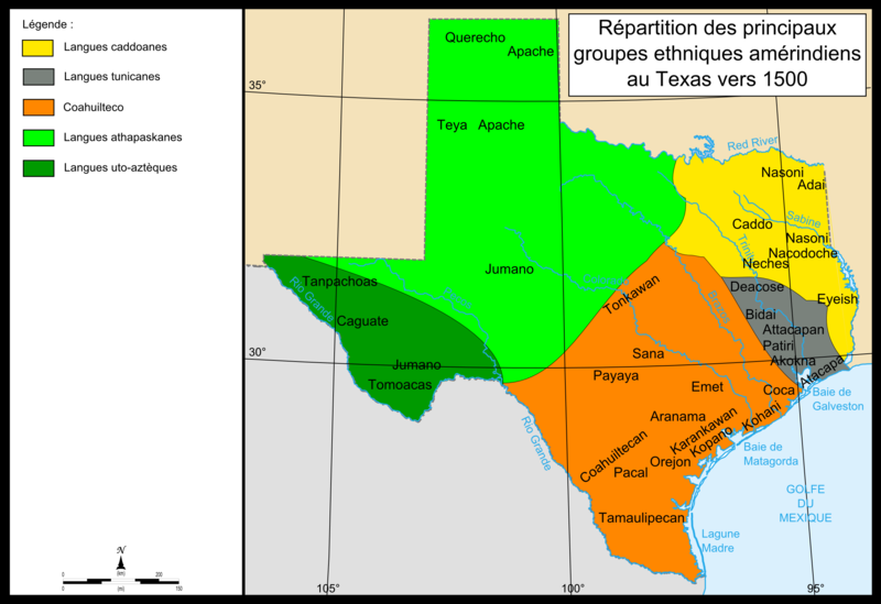
| Description | Map of Texas showing the location of Indian groups around 1500 as well as colors showing regions in which specific Indian languages were spoken. The Southwest of Texas is colored dark green for Lagues uo-azteques, and the groups in this region are Tanpachaos, Caguate, Jumano, and Tomoacas. The northwest is colored lime green for the Langues Athapaskanes and the groups in this area are the Querecho, Apache, Teya, and Jumano. The large southern section in the middle of the map is colored orange for Coahuilteco, and the groups in this region are the Tonkawan, Sana, Payaya, Emet, Coca, Aranama, Coahuiltecan, Karankawan, Kopano, Kahani, Orejon, Pacal, and Tamaulipecan. A small eastern section along the coast is colored grey for Langues tunicanes, and includes the groups Deacose, Bidai, Attacapan, Patiri, Akokna, and Atacapa. The northeast of the state is colored yellow for Langues caddoanes, and contains the groups of Nasoni, Caddo, Adai, Nacodoche, Neches, and Eyeish. |
| Date | ༡༣ ཟླ་བ་དགུ་བ། ༢༠༠༨ (original upload date) |
| Source | No machine-readable source provided. Own work assumed (based on copyright claims). |
| Author | No machine-readable author provided. Urban~commonswiki assumed (based on copyright claims). |
གན་རྒྱ་ནང་ཞུགས་པ།
| I, the copyright holder of this work, release this work into the public domain. This applies worldwide. In some countries this may not be legally possible; if so: I grant anyone the right to use this work for any purpose, without any conditions, unless such conditions are required by law. |
ཡིག་ཆའི་ལོ་རྒྱུས།
ཟླ་ཚེས་/དུས་ཚོད་གནུན་ཏེ་རྩོམ་ཡིག་ལ་ལྟ་བ།
| ཚེས་གྲངས། / དུས་ཚོད། | བསྡུས་དོན། | ཚད། | སྤྱོད་མི། | བསམ་ཚུལ། | |
|---|---|---|---|---|---|
| ད་ལྟ། | ༡༥:༡༠, ༡༣ ཟླ་དགུ་བ། ༢༠༠༨ | | ༢,༣༠༨ × ༡,༥༨༤ (༥༢༡ KB) | Urban~commonswiki | category:maps of Texas |
ཡིག་ཆ་བེད་སྤྱོད་ཁུལ།
pagelinks འདི་ལ་སྦྲེལ་ཡོད།
Global file usage
The following other wikis use this file:
- Usage on ca.wikipedia.org
- Usage on en.wikipedia.org
- Usage on es.wikipedia.org
- Usage on fr.wikipedia.org
- Usage on it.wikipedia.org
- Usage on sr.wikipedia.org
- Usage on tr.wikipedia.org