
File:Berninabahn zwischen Lagalb und Ospizio Bernina im Winter.jpg

Size of this preview: ༨༠༠ × ༤༩༣ pixels. Other resolutions: ༣༢༠ × ༡༩༧ pixels | ༦༤༠ × ༣༩༤ pixels | ༡,༠༢༤ × ༦༣༡ pixels | ༡,༢༨༠ × ༧༨༨ pixels | ༣,༡༤༤ × ༡,༩༣༦ pixels.
ཐོག་མའི་ཡིག་ཆ། (༣,༡༤༤ × ༡,༩༣༦ བརྙན་རྒྱུ།, ཡིག་ཆ་ཆེ་ཆུང།: ༡.༠༧ MB, རྣམ་གཞག།: image/jpeg)
བསྡུས་དོན།
| Description |
Deutsch: Regionalzug auf der Berninalinie zwischen Lagalb und Ospizio Bernina. Die beiden ABe 4/4-Triebwagen (vorne ABe 4/4II, hinten ABe 4/4III) haben mehr als genug Leistung für zwei Personenwagen, daher werden noch zwei Güterwagen mitgeführt.
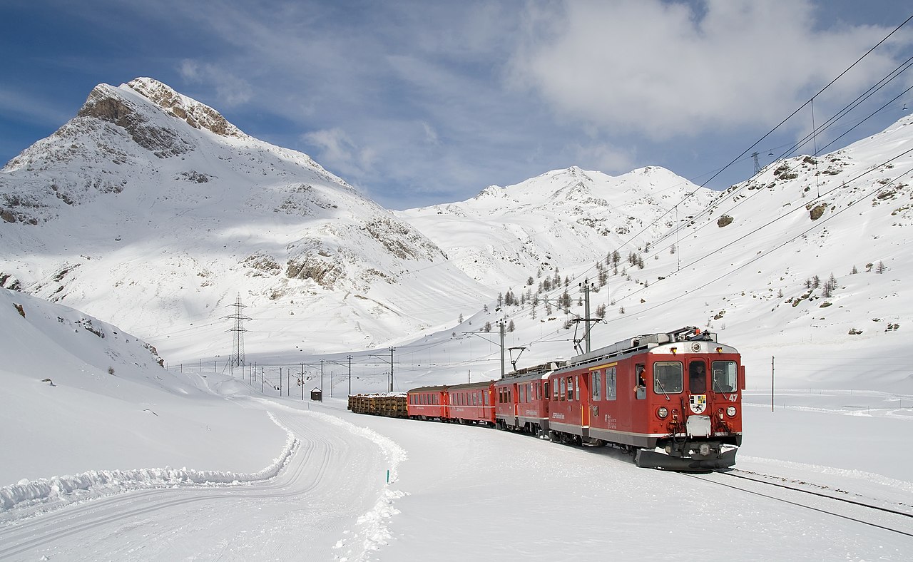
English: Local train on the Bernina line between Lagalb and Ospizio Bernina pulled by two ABe 4/4 multiple units (an ABe 4/4 II leading an ABe 4/4 III). The two multiple units have excess power with only two passenger cars, so some freight is carried along.
Español: Tren en la línea de Bernina Express entre Lagalb y Ospizio Bernina tirado por dos unidades de tren ABe 4/4. Las dos unidades tienen un exceso de potencia con sólo dos coches turismos, por lo que lleva algunos vagones de carga.
Français : Train local sur la ligne Bernina Express entre Lagalb et Ospizio Bernina tracté par deux locomotives ABe 4/4. Les deux locomotives sont en excès de puissance avec seulement deux wagons de passagers, si bien que deux wagons de marchandise ont été ajoutés.
Italiano: Un treno regionale (con in testa due automotrici ABe 4/4 II e III) sulla ferrovia del Bernina, che collega Tirano a Sankt Moritz, in prossimità del valico alpino svizzero del Bernina. La ferrovia del Bernina è la più alta linea ferroviaria ad aderenza naturale delle Alpi ed è inclusa nell'elenco dei Patrimoni dell'umanità stilato dall'UNESCO
Русский: Поезд на линии Berninabahn Ретийской железной дороги в Швейцарии ведут два электровоза. В составе поезда пассажирские и грузовые вагоны. |
| Date | |
| Source | Own work: http://www.bahnbilder.ch/picture/215 |
| Author | Kabelleger / David Gubler |
| Other versions | Derivative works of this file: Berninabahn banner.jpg |
| Camera location | | View this and other nearby images on: OpenStreetMap |
|---|
|

This image was selected as picture of the day on Wikimedia Commons for 17 April 2010. It was captioned as follows: English: Local train on the Bernina Express line between Lagalb and Ospizio Bernina pulled by two ABe 4/4 multiple units (an ABe 4/4 II leading an ABe 4/4 III). The two multiple units have excess power with only two passenger cars, so some freight is carried along. Other languages:
Català: Tren regional amb dos automotors en la línia de Bernina durant l'hivern, prop del coll de Bernina (2.253 m) als Alps suïssos. Čeština: Vlak Berninabahn mezi horou Lagalb a průsmykem Bernina hnaný dvěma elektrickými jednotkami Abe 4/4 (první ABe 4/4 II, druhá ABe 4/4 III) Dansk: Lokaltog på linjen Bernina Express mellem Lagalb og Ospizio Bernina. Det trækkes af to ABe 4/4-lokomotiver. Disse har overskydende trækkraft ved kun at medføre to passagervogne, hvorfor to fragtvogne er føjet til togstammen. Deutsch: Regionalzug auf der Berninalinie zwischen Lagalb und Ospizio Bernina. Die beiden ABe 4/4-Triebwagen (vorne ABe 4/4 II, hinten ABe 4/4 III) haben mehr als genug Leistung für zwei Personenwagen, daher werden noch zwei Güterwagen mitgeführt. English: Local train on the Bernina Express line between Lagalb and Ospizio Bernina pulled by two ABe 4/4 multiple units (an ABe 4/4 II leading an ABe 4/4 III). The two multiple units have excess power with only two passenger cars, so some freight is carried along. Español: Tren en la línea de Bernina Express entre Lagalb y Ospizio Bernina tirado por dos unidades de tren ABe 4/4. Las dos unidades tienen un exceso de potencia con sólo dos coches turismos, por lo que lleva algunos vagones de carga. Esperanto: loka trajno de la bernina linio de la Retia Fervojo en Svislando, liganta la lokojn Tirano kaj Sankta Maŭrico (Sankt Moritz), proksime de la Berninopasejo Français : Train local sur la ligne Bernina Express entre Lagalb et Ospizio Bernina tracté par deux automotrices ABe 4/4. Les deux automotrices sont en excès de puissance avec seulement deux wagons de passagers, si bien que deux wagons de marchandise ont été ajoutés. Italiano: Un treno regionale (con in testa due automotrici ABe 4/4 II e III) sulla ferrovia del Bernina, che collega Tirano a Sankt Moritz, in prossimità del valico alpino svizzero del Bernina. La ferrovia del Bernina è la più alta linea ferroviaria ad aderenza naturale delle Alpi ed è inclusa nell'elenco dei Patrimoni dell'umanità stilato dall'UNESCO Magyar: Helyi vonat a Bernina-expressz vonalán Lagalb és Ospizio Bernina között. A kocsikat két ABe 4/4 mozdony vontatja. Nederlands: Regionale trein op de Bernina-Bahn tussen de stations Lagalb en Ospizio Bernina (twee bergen) in oostelijk Zwitserland. De beide ABe 4/4-treinstellen (voor: ABe 4/4 II, achter: ABe 4/4 III) hebben meer dan genoeg vermogen voor de twee spoorwegrijtuigen en daarom worden ook twee goederenwagons meegevoerd. Македонски: Воз на месната линија „Бернина Експрес“ помеѓу планината Лагалб и преслапот Бернина, Швајцарија. বাংলা : সুইজারল্যান্ডের ল্যাগলাব ও ওসপিজিও বার্নিয়ার মধ্যে সংযোগকৃত বার্নিয়া এক্সপ্রেস রেললাইন। 日本語: ベルニナ急行の運転で知られるレーティッシュ鉄道の普通列車。2両のABe 4/4形電車(前部がABe 4/4 II形、後部がABe 4/4 III形)が、客車と貨車を2両ずつ牽引している。Lagalb 駅・Ospizio Bernina 駅間にて。 |
གན་རྒྱ་ནང་ཞུགས་པ།
| I, the copyright holder of this work, release this work into the public domain. This applies worldwide. In some countries this may not be legally possible; if so: I grant anyone the right to use this work for any purpose, without any conditions, unless such conditions are required by law. |
| Annotations | This image is annotated: View the annotations at Commons |
ཡིག་ཆའི་ལོ་རྒྱུས།
ཟླ་ཚེས་/དུས་ཚོད་གནུན་ཏེ་རྩོམ་ཡིག་ལ་ལྟ་བ།
| ཚེས་གྲངས། / དུས་ཚོད། | བསྡུས་དོན། | ཚད། | སྤྱོད་མི། | བསམ་ཚུལ། | |
|---|---|---|---|---|---|
| ད་ལྟ། | ༢༣:༡༩, ༨ ཟླ་གཉིས་པ། ༢༠༡༠ | | ༣,༡༤༤ × ༡,༩༣༦ (༡.༠༧ MB) | Kabelleger | New version with (hopefully) better white balance |
| ༡༨:༥༨, ༤ ཟླ་བཅུ་བ། ༢༠༠༩ |  | ༢,༧༣༢ × ༡,༧༡༢ (༨༦༦ KB) | Kabelleger | ||
| ༢༠:༢༥, ༢༨ ཟླ་དགུ་བ། ༢༠༠༨ |  | ༣,༤༥༦ × ༢,༣༠༤ (༦༨༧ KB) | Kabelleger | {{Information |Description={{en|1=Local train on the Bernina line between Lagalb and Ospizio Bernina pulled by two ABe 4/4 multiple units. The two multiple units have excess power with only two passenger cars, so some freight is carried along.}} {{de|1=Re |
ཡིག་ཆ་བེད་སྤྱོད་ཁུལ།
There are no pages that use this file.
Global file usage
The following other wikis use this file:
- Usage on als.wikipedia.org
- Usage on am.wikipedia.org
- Usage on ar.wikipedia.org
- Usage on arz.wikipedia.org
- Usage on ast.wikipedia.org
- Usage on bat-smg.wikipedia.org
- Usage on bg.wikipedia.org
- Usage on bh.wikipedia.org
- Usage on bn.wikipedia.org
- Usage on bxr.wikipedia.org
- Usage on ca.wikipedia.org
- Usage on ceb.wikipedia.org
- Usage on crh.wikipedia.org
- Usage on cv.wikipedia.org
- Usage on de.wikipedia.org
- Usage on ee.wikipedia.org
- Usage on el.wikipedia.org
- Usage on el.wiktionary.org
- Usage on en.wikipedia.org
- Wikipedia:WikiProject Trains
- Valtellina
- User talk:Kabelleger
- Wikipedia:Featured pictures/Places/Others
- Piz Minor
- Bernina railway line
- Talk:Bernina railway line
- Wikipedia:Featured pictures thumbs/60
- Wikipedia:Wikipedia Signpost/2017-06-09/Featured content
- Wikipedia:Featured picture candidates/April-2017
- Wikipedia:Featured picture candidates/Train on the Bernina line, Switzerland
- Wikipedia:Wikipedia Signpost/Single/2017-06-09
- User talk:Bruce1ee/Archive 11
- Wikipedia:WikiProject Trains/Featured content
- User:Amakuru/POTD 1
- Wikipedia:Picture of the day/December 2020
- Portal:Trains/Selected picture/2020 archive
- Portal:Trains/Selected picture/Week 52, 2020
- Template:POTD/2020-12-11
- Wikipedia:Main Page history/2020 December 11
- Wikipedia:Main Page history/2020 December 11b
- Portal:Trains/Selected picture candidates/Berninabahn zwischen Lagalb und Ospizio Bernina im Winter.jpg
- User talk:Bruce1ee/Archive 14
View more global usage of this file.