
File:Tibetan empire greatest extent 780s-790s CE.png

Size of this preview: ༧༩༠ × ༦༠༠ pixels. Other resolutions: ༣༡༦ × ༢༤༠ pixels | ༦༣༢ × ༤༨༠ pixels | ༡,༠༡༡ × ༧༦༨ pixels | ༡,༢༨༠ × ༩༧༢ pixels | ༡,༧༩༢ × ༡,༣༦༡ pixels.
ཐོག་མའི་ཡིག་ཆ། (༡,༧༩༢ × ༡,༣༦༡ བརྙན་རྒྱུ།, ཡིག་ཆ་ཆེ་ཆུང།: ༤.༥༥ MB, རྣམ་གཞག།: image/png)
བསྡུས་དོན།

|
This historical map image could be re-created using vector graphics as an SVG file. This has several advantages; see Commons:Media for cleanup for more information. If an SVG form of this image is available, please upload it and afterwards replace this template with
{{vector version available|new image name}}.
It is recommended to name the SVG file “Tibetan empire greatest extent 780s-790s CE.svg”—then the template Vector version available (or Vva) does not need the new image name parameter. |
| Description |
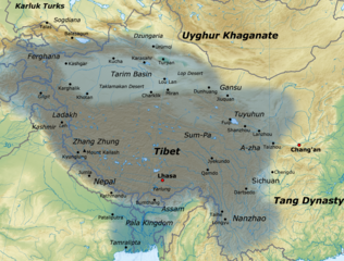
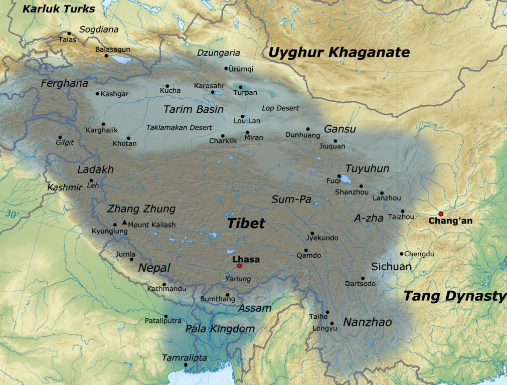
English: Map of the Tibetan Empire at its greatest extent between the 780s and the 790s CE
sources:
|
| Date | |
| Source | Own work |
| Author | Javierfv1212 |
གན་རྒྱ་ནང་ཞུགས་པ།
I, the copyright holder of this work, hereby publish it under the following license:
This file is licensed under the Creative Commons Attribution 3.0 Unported license.
- You are free:
- to share – to copy, distribute and transmit the work
- to remix – to adapt the work
- Under the following conditions:
- attribution – You must give appropriate credit, provide a link to the license, and indicate if changes were made. You may do so in any reasonable manner, but not in any way that suggests the licensor endorses you or your use.
ཡིག་ཆའི་ལོ་རྒྱུས།
ཟླ་ཚེས་/དུས་ཚོད་གནུན་ཏེ་རྩོམ་ཡིག་ལ་ལྟ་བ།
| ཚེས་གྲངས། / དུས་ཚོད། | བསྡུས་དོན། | ཚད། | སྤྱོད་མི། | བསམ་ཚུལ། | |
|---|---|---|---|---|---|
| ད་ལྟ། | ༡༦:༡༡, ༡༦ ཟླ་དང་པོ། ༢༠༢༡ | | ༡,༧༩༢ × ༡,༣༦༡ (༤.༥༥ MB) | Liandrei | Cropped black border |
| ༡༦:༠༠, ༢༩ ཟླ་གསུམ། ༢༠༡༡ |  | ༡,༨༠༠ × ༡,༣༦༡ (༤.༥༦ MB) | Javierfv1212 | {{Information |Description ={{en|1=Map of the Tibetan empire at it's Greatest extent between the 780s and the 790s CE sources: http://academic.reed.edu/anthro/364/maps.html http://unitednations4freetibet.com/unfft/wp-content/uploads/2010/11/The-Nation |
ཡིག་ཆ་བེད་སྤྱོད་ཁུལ།
3pagelink འདི་ལ་སྦྲེལ་ཡོད།
Global file usage
The following other wikis use this file:
- Usage on af.wikipedia.org
- Usage on ar.wikipedia.org
- Usage on azb.wikipedia.org
- Usage on az.wikipedia.org
- Usage on ba.wikipedia.org
- Usage on bg.wikipedia.org
- Usage on bn.wikipedia.org
- Usage on bs.wikipedia.org
- Usage on ca.wikipedia.org
- Usage on cs.wikipedia.org
- Usage on da.wikipedia.org
- Usage on de.wikipedia.org
- Usage on en.wikipedia.org
- Usage on es.wikipedia.org
- Usage on eu.wikipedia.org
- Usage on fa.wikipedia.org
- Usage on fi.wikipedia.org
- Usage on fr.wikipedia.org
- Xinjiang
- Christianisme au Tibet
- Empire du Tibet
- Discussion:Empire du Tibet
- Wikipédia:Statistiques des anecdotes de la page d'accueil/Visibilité des anecdotes (2020)
- Discussion:Empire du Tibet/LSV 19247
- Wikipédia:Statistiques des anecdotes de la page d'accueil/Visibilité des anecdotes (2020)/2020 10
- Projet:Aide et accueil/Twitter/Tweets/archives/octobre 2020
- Wikipédia:Le saviez-vous ?/Archives/2020
View more global usage of this file.