
File:Shigatse map.svg

Size of this PNG preview of this SVG file: ༨༠༠ × ༥༥༧ pixels. Other resolutions: ༣༢༠ × ༢༢༣ pixels | ༦༤༠ × ༤༤༦ pixels | ༡,༠༢༤ × ༧༡༣ pixels | ༡,༢༨༠ × ༨༩༢ pixels | ༢,༥༦༠ × ༡,༧༨༤ pixels | ༡,༥༢༠ × ༡,༠༥༩ pixels.
ཐོག་མའི་ཡིག་ཆ། (SVG file, nominally ༡,༥༢༠ × ༡,༠༥༩ pixels, file size: ༡༨༣ KB)
བསྡུས་དོན།
| Description |
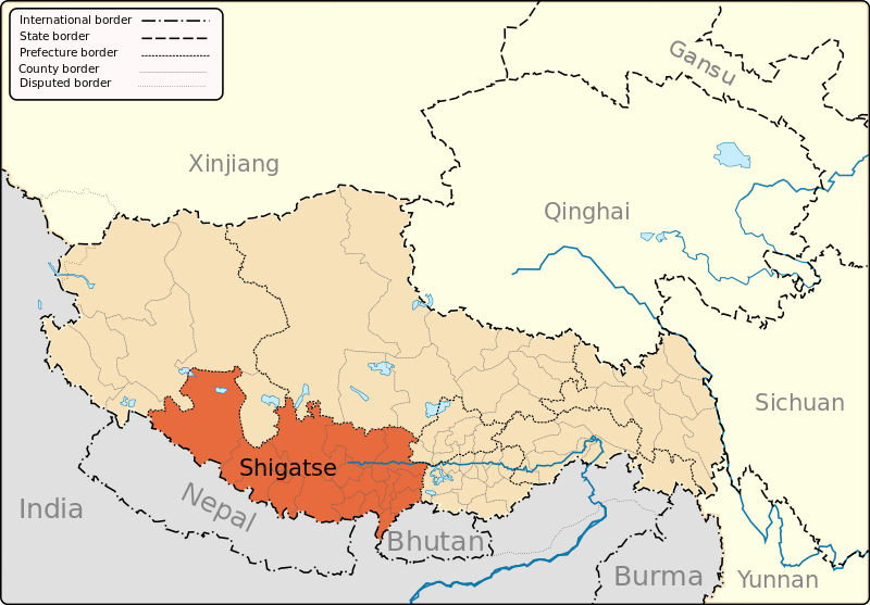
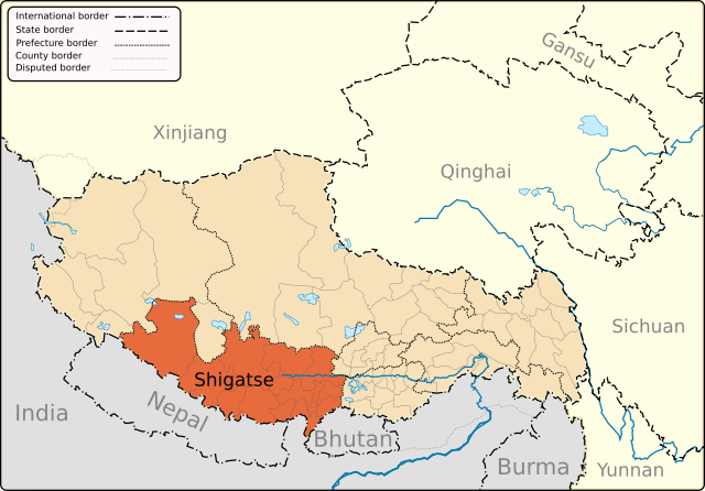
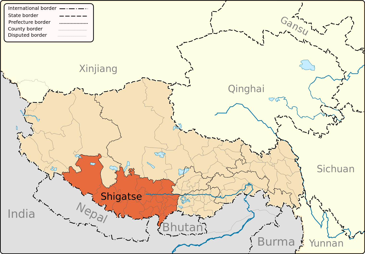
English: A map of the administrative boundaries of The Tibetan Autonomous Region with Shigatse Prefecture highlighted. |
| Date | |
| Source | Own work |
| Author | Keithonearth |
| Other versions |
|
| SVG genesis |


གན་རྒྱ་ནང་ཞུགས་པ།
I, the copyright holder of this work, hereby publish it under the following licenses:
This file is licensed under the Creative Commons Attribution-Share Alike 3.0 Unported license.
- You are free:
- to share – to copy, distribute and transmit the work
- to remix – to adapt the work
- Under the following conditions:
- attribution – You must give appropriate credit, provide a link to the license, and indicate if changes were made. You may do so in any reasonable manner, but not in any way that suggests the licensor endorses you or your use.
- share alike – If you remix, transform, or build upon the material, you must distribute your contributions under the same or compatible license as the original.

|
Permission is granted to copy, distribute and/or modify this document under the terms of the GNU Free Documentation License, Version 1.2 or any later version published by the Free Software Foundation; with no Invariant Sections, no Front-Cover Texts, and no Back-Cover Texts. A copy of the license is included in the section entitled GNU Free Documentation License. |
You may select the license of your choice.
ཡིག་ཆའི་ལོ་རྒྱུས།
ཟླ་ཚེས་/དུས་ཚོད་གནུན་ཏེ་རྩོམ་ཡིག་ལ་ལྟ་བ།
| ཚེས་གྲངས། / དུས་ཚོད། | བསྡུས་དོན། | ཚད། | སྤྱོད་མི། | བསམ་ཚུལ། | |
|---|---|---|---|---|---|
| ད་ལྟ། | ༢༠:༡༧, ༡༢ ཟླ་གསུམ། ༢༠༡༣ | | ༡,༥༢༠ × ༡,༠༥༩ (༡༨༣ KB) | Keithonearth | fixing Ngari/Shigatse prefecture boundary as pointed out by user:Fhah4 as per comment here: http://en.wikipedia.org/w/index.php?title=Wikipedia:Graphics_Lab/Map_workshop&diff=541288793&oldid=541266575 |
| ༠༥:༠༩, ༣༡ ཟླ་བཅུ་གཉིས་པ། ༢༠༠༨ |  | ༡,༥༢༠ × ༡,༠༥༩ (༢༡༡ KB) | Keithonearth | Changing colour scheme to make more sense, progression from non-highlighted to most highlighted Category:Tibet | |
| ༠༢:༢༦, ༣༠ ཟླ་བཅུ་གཉིས་པ། ༢༠༠༨ |  | ༡,༥༢༠ × ༡,༠༥༩ (༢༡༡ KB) | Keithonearth | {{Information |Description={{en|1=A map of the administrative boundaries of The Tibetan Autonomous Region with Shigatse Prefecture highlighted.}} |Source=Own work by uploader |Author=Keithonearth |Date=2008-12-29 |Permission= |other_ |
ཡིག་ཆ་བེད་སྤྱོད་ཁུལ།
pagelinks འདི་ལ་སྦྲེལ་ཡོད།
Global file usage
The following other wikis use this file:
- Usage on ar.wikipedia.org
- Usage on bn.wikipedia.org
- Usage on cdo.wikipedia.org
- Usage on cs.wikipedia.org
- Usage on da.wikipedia.org
- Usage on en.wikipedia.org
- Samzhubzê, Xigazê
- Shigatse
- Tingri (town)
- Yadong County
- Shelkar
- Phari
- Milarepa's Cave, Nyalam
- Nyalam Town
- Nyalam County
- Gyantse County
- Zhangmu
- Template:Xigazê
- Bainang County
- Kamba County
- Gyirong County
- Rinbung County
- Kangmar County
- Lhatse County
- Namling County
- Ngamring County
- Sa'gya County
- Tingri County
- Xaitongmoin County
- Zhongba County
- Dinggyê County
- Saga County
- Lhatse (town)
- Bangxing
- Zazê Township
- Drakna Township
- Congdü
- Nailung Township
- Parjang Township
- Raka, Tibet
- Ramba Township
- Sengli Co
- Namling
- Manmogang Monastery
- Saga, Tibet
- Jiesa Lake
- Dajia Lake
- Taruo Lake
- Renqingxiubu Lake
- Ang Laren Lake
- Wikipedia:Graphics Lab/Map workshop/Archive/Mar 2013
View more global usage of this file.