
File:Saint Petersburg 1776 map LOC g7064s ct001468.jpg

Size of this preview: ༨༠༠ × ༥༡༡ pixels. Other resolutions: ༣༢༠ × ༢༠༤ pixels | ༦༤༠ × ༤༠༩ pixels | ༡,༠༢༤ × ༦༥༤ pixels | ༡,༢༨༠ × ༨༡༨ pixels | ༢,༥༦༠ × ༡,༦༣༥ pixels | ༨,༣༢༨ × ༥,༣༢༠ pixels.
ཐོག་མའི་ཡིག་ཆ། (༨,༣༢༨ × ༥,༣༢༠ བརྙན་རྒྱུ།, ཡིག་ཆ་ཆེ་ཆུང།: ༦.༩༩ MB, རྣམ་གཞག།: image/jpeg)
| Description |
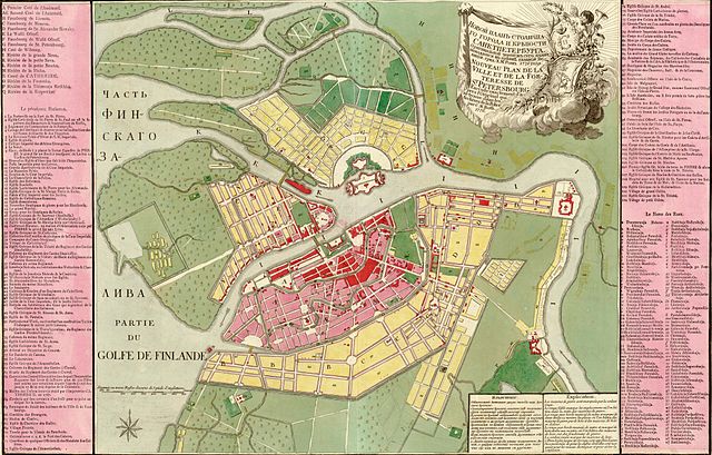
Русский: Novoi plan stolichnago goroda i krieposti Sanktpeterburga. Grid: Kh. M. Rot. Français : Nouveau plan de la ville et de la forteresse de St. Pétersbourg, exécuté exactement d'apres l'original qui se trouve dans les archives de la Police. Par C. M. Roth. English: New Map of the city and the fortress of St Petersburg, drawn exactly according to the original file in the archives of the Police. By C.M. Roth. |
||||
| Date | |||||
| Source | Library of Congress Geography and Map Division Washington; http://memory.loc.gov/ammem/gmdhtml/gmdhome.html | ||||
| Author | C. M. Roth. | ||||
| Permission (Reusing this file) |
|
||||
| Other versions |
 |
||||

|
This map is available from the United States Library of Congress's Geography & Map Division
under the digital ID g7064s.ct001468. This tag does not indicate the copyright status of the attached work. A normal copyright tag is still required. See Commons:Licensing.
|
ཡིག་ཆའི་ལོ་རྒྱུས།
ཟླ་ཚེས་/དུས་ཚོད་གནུན་ཏེ་རྩོམ་ཡིག་ལ་ལྟ་བ།
| ཚེས་གྲངས། / དུས་ཚོད། | བསྡུས་དོན། | ཚད། | སྤྱོད་མི། | བསམ་ཚུལ། | |
|---|---|---|---|---|---|
| ད་ལྟ། | ༠༥:༤༩, ༩ ཟླ་བཅུ་གཅིག་པ། ༢༠༠༦ | | ༨,༣༢༨ × ༥,༣༢༠ (༦.༩༩ MB) | Balcer~commonswiki | Novoi plan stolichnago goroda i krieposti Sanktpeterburga. Nouveau plan de la ville et de la forteresse de St. Pétersbourg. Grid: Kh. M. Rot. Par C. M. Roth. Published in 1776. {{PD-LOC}} {{LOC-image|id=g7064s.ct001468 }} |
ཡིག་ཆ་བེད་སྤྱོད་ཁུལ།
pagelinks འདི་ལ་སྦྲེལ་ཡོད།
Global file usage
The following other wikis use this file:
- Usage on fi.wikipedia.org
- Usage on fr.wikipedia.org
- Usage on gl.wikipedia.org
- Usage on ka.wikipedia.org
- Usage on pl.wikipedia.org
- Usage on ru.wikipedia.org
- Usage on uk.wikipedia.org