
File:Orange watershed topo.png
Size of this preview: ༨༠༠ × ༥༡༥ pixels. Other resolutions: ༣༢༠ × ༢༠༦ pixels | ༦༤༠ × ༤༡༢ pixels | ༡,༡༥༠ × ༧༤༡ pixels.
ཐོག་མའི་ཡིག་ཆ། (༡,༡༥༠ × ༧༤༡ བརྙན་རྒྱུ།, ཡིག་ཆ་ཆེ་ཆུང།: ༥༥༦ KB, རྣམ་གཞག།: image/png)
བསྡུས་དོན།
| Description |
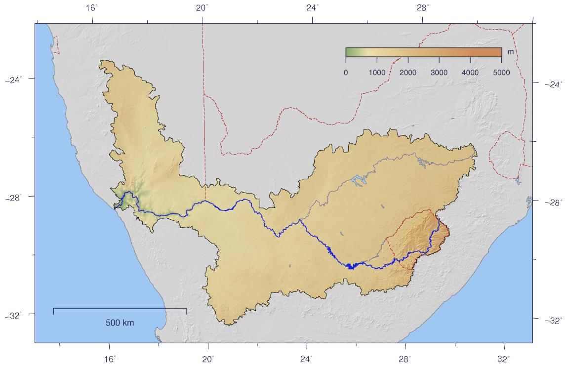
English: Course and Watershed of the Orange River with topography shading and political boundaries.
Deutsch: Verlauf und Einzugsgebiet des Oranje mit Reliefschattierung und Staatsgrenzen.
Afrikaans: Die Oranje-, Caledon- en Vaalriviere, uitgebeeld met hul opvanggebied |
| Date | |
| Source | The map has been created with the Generic Mapping Tools: http://gmt.soest.hawaii.edu/ using additional public comain data from the VMAP0 data set. |
| Author | Imagico |
| Permission (Reusing this file) |
This file is licensed under the Creative Commons Attribution-Share Alike 2.5 Generic license.
|
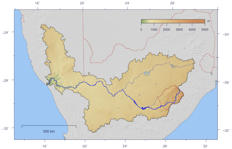
| Other versions | Image:Orange_watershed_plain.png |
གན་རྒྱ་ནང་ཞུགས་པ།
I, the copyright holder of this work, hereby publish it under the following license:
This file is licensed under the Creative Commons Attribution-Share Alike 2.5 Generic license.
- You are free:
- to share – to copy, distribute and transmit the work
- to remix – to adapt the work
- Under the following conditions:
- attribution – You must give appropriate credit, provide a link to the license, and indicate if changes were made. You may do so in any reasonable manner, but not in any way that suggests the licensor endorses you or your use.
- share alike – If you remix, transform, or build upon the material, you must distribute your contributions under the same or compatible license as the original.
ཡིག་ཆའི་ལོ་རྒྱུས།
ཟླ་ཚེས་/དུས་ཚོད་གནུན་ཏེ་རྩོམ་ཡིག་ལ་ལྟ་བ།
| ཚེས་གྲངས། / དུས་ཚོད། | བསྡུས་དོན། | ཚད། | སྤྱོད་མི། | བསམ་ཚུལ། | |
|---|---|---|---|---|---|
| ད་ལྟ། | ༡༥:༠༨, ༢༥ ཟླ་གཉིས་པ། ༢༠༠༧ | | ༡,༡༥༠ × ༧༤༡ (༥༥༦ KB) | Imagico | {{Information |Description= {{en|Course and Watershed of the Orange River with topography shading and political boundaries.}} {{de|Verlauf und Einzugsgebiet des Oranje mit Reliefschattierung und Staatsgrenzen.}} |Source=The map has been created with the [ |
ཡིག་ཆ་བེད་སྤྱོད་ཁུལ།
pagelinks འདི་ལ་སྦྲེལ་ཡོད།
Global file usage
The following other wikis use this file:
- Usage on ar.wikipedia.org
- Usage on azb.wikipedia.org
- Usage on ba.wikipedia.org
- Usage on bg.wikipedia.org
- Usage on bs.wikipedia.org
- Usage on cs.wikipedia.org
- Usage on cy.wikipedia.org
- Usage on da.wikipedia.org
- Usage on de.wikipedia.org
- Usage on el.wikipedia.org
- Usage on en.wikipedia.org
- Usage on eo.wikipedia.org
- Usage on es.wikipedia.org
- Usage on fa.wikipedia.org
- Usage on fr.wikipedia.org
- Usage on fy.wikipedia.org
- Usage on ha.wikipedia.org
- Usage on hi.wikipedia.org
- Usage on hu.wikipedia.org
- Usage on hy.wikipedia.org
- Usage on it.wikipedia.org
- Usage on ja.wikipedia.org
- Usage on ka.wikipedia.org
- Usage on ko.wikipedia.org
- Usage on ky.wikipedia.org
- Usage on ml.wikipedia.org
- Usage on nl.wikipedia.org
- Usage on no.wikipedia.org
- Usage on nso.wikipedia.org
- Usage on pl.wikipedia.org
- Usage on pt.wikipedia.org
- Usage on ru.wikipedia.org
- Usage on sh.wikipedia.org
- Usage on sk.wikipedia.org
- Usage on sl.wikipedia.org
- Usage on sr.wikipedia.org
- Usage on st.wikipedia.org
- Usage on sv.wikipedia.org
- Usage on tt.wikipedia.org
- Usage on uk.wikipedia.org
View more global usage of this file.