
File:Noahsworld map.png

Size of this preview: ༤༠༢ × ༥༩༩ pixels. Other resolutions: ༡༦༡ × ༢༤༠ pixels | ༣༢༢ × ༤༨༠ pixels.
ཐོག་མའི་ཡིག་ཆ། (༨༠༠ × ༡,༡༩༢ བརྙན་རྒྱུ།, ཡིག་ཆ་ཆེ་ཆུང།: ༣༣༧ KB, རྣམ་གཞག།: image/png)
| Description |
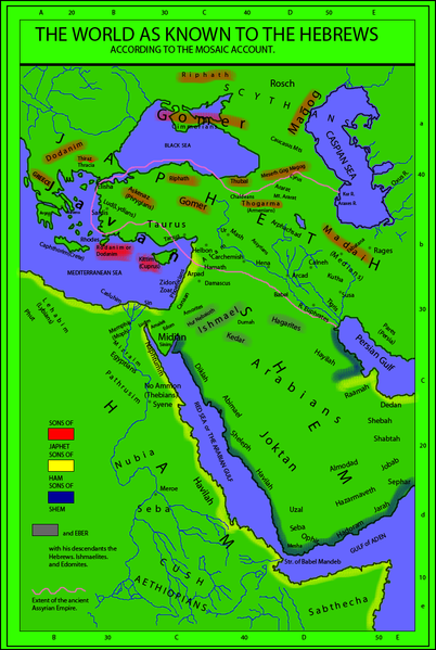
English: The world as known to the Hebrews. A map from "Historical Textbook and Atlas of Biblical Geography (1854)" by Lyman Coleman |
||||||||||||||
| Date | |||||||||||||||
| Source |
|
||||||||||||||
| Author |
|
||||||||||||||
| Permission (Reusing this file) |
|
||||||||||||||
| Other versions |
This map derives from a 1854 map   |
||||||||||||||
_(14793127233)_(cropped).jpg)
ཡིག་ཆའི་ལོ་རྒྱུས།
ཟླ་ཚེས་/དུས་ཚོད་གནུན་ཏེ་རྩོམ་ཡིག་ལ་ལྟ་བ།
| ཚེས་གྲངས། / དུས་ཚོད། | བསྡུས་དོན། | ཚད། | སྤྱོད་མི། | བསམ་ཚུལ། | |
|---|---|---|---|---|---|
| ད་ལྟ། | ༢༠:༡༨, ༡༩ ཟླ་གཉིས་པ། ༢༠༡༠ | | ༨༠༠ × ༡,༡༩༢ (༣༣༧ KB) | Megistias | Added, Zidon, Zoar, Arpad, Aram, Arphachsad, Mash, Carchemish, Calneh, (Armenians) parentheses in Medians. Ludim, Amalek, Edom, Midian and Sinim. Kaspian, Kur R., |
| ༡༤:༤༠, ༡༩ ཟླ་གཉིས་པ། ༢༠༡༠ |  | ༨༠༠ × ༡,༡༩༢ (༣༣༡ KB) | Megistias | {{Information |Description={{en|The World as known to the Hebrews. A map from Historical Textbook and Atlas of Biblical Geography (1854) by Coleman}} |Source= *map from Historical Textbook and Atlas of Biblical Geography (1854) by Coleman *Historical Orig |
ཡིག་ཆ་བེད་སྤྱོད་ཁུལ།
pagelinks འདི་ལ་སྦྲེལ་ཡོད།
Global file usage
The following other wikis use this file:
- Usage on en.wikipedia.org
- Usage on ko.wikipedia.org