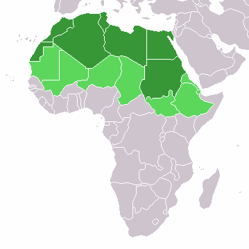
File:LocationNorthernAfrica.png
LocationNorthernAfrica.png (༣༥༩ × ༣༥༩ བརྙན་རྒྱུ།, ཡིག་ཆ་ཆེ་ཆུང།: ༨ KB, རྣམ་གཞག།: image/png)
ཡིག་ཆའི་ལོ་རྒྱུས།
ཟླ་ཚེས་/དུས་ཚོད་གནུན་ཏེ་རྩོམ་ཡིག་ལ་ལྟ་བ།
| ཚེས་གྲངས། / དུས་ཚོད། | བསྡུས་དོན། | ཚད། | སྤྱོད་མི། | བསམ་ཚུལ། | |
|---|---|---|---|---|---|
| ད་ལྟ། | ༡༣:༡༦, ༡༡ ཟླ་བཅུ་གཅིག་པ། ༢༠༢༢ |  | ༣༥༩ × ༣༥༩ (༨ KB) | ColorfulSmoke | . |
| ༡༡:༥༤, ༡༡ ཟླ་བཅུ་གཅིག་པ། ༢༠༢༢ |  | ༣༦༠ × ༣༥༩ (༨ KB) | ColorfulSmoke | ||
| ༡༦:༥༧, ༡༧ ཟླ་གསུམ། ༢༠༡༨ |  | ༣༦༠ × ༣༩༢ (༡༠ KB) | Maphobbyist | Montenegro border | |
| ༡༨:༡༩, ༡༠ ཟླ་གཉིས་པ། ༢༠༡༤ |  | ༣༦༠ × ༣༩༢ (༨ KB) | Knyaz-1988 | New version | |
| ༠༥:༠༥, ༡༢ ཟླ་དང་པོ། ༢༠༡༣ |  | ༣༦༠ × ༣༩༢ (༡༣ KB) | Kuohatti | Reverted to version as of 21:04, 9 July 2011. According to http://unstats.un.org/unsd/methods/m49/m49regin.htm#africa UN doesn't count South Sudan in North Africa. | |
| ༡༢:༤༧, ༢༠ ཟླ་བདུན་པ། ༢༠༡༡ |  | ༣༦༠ × ༣༩༢ (༨ KB) | Kahusi | See http://unstats.un.org/unsd/methods/m49/m49regin.htm | |
| ༢༡:༠༤, ༩ ཟླ་བདུན་པ། ༢༠༡༡ |  | ༣༦༠ × ༣༩༢ (༡༣ KB) | Maphobbyist | South Sudan has become independent on July 9, 2011. Sudan and South Sudan are shown with the new international border between them. | |
| ༡༨:༥༥, ༢༧ ཟླ་ལྔ་བ། ༢༠༠༩ |  | ༣༦༠ × ༣༩༢ (༡༤ KB) | Elmondo21st | Reverted to version as of 08:13, 11 December 2007 | |
| ༡༨:༡༣, ༥ ཟླ་བཞི་བ། ༢༠༠༩ |  | ༣༦༠ × ༣༩༢ (༡༤ KB) | Elmondo21st | The map of the northern Africa is about 5 main countries; Morocco, Algeria, Tunisia, Libya and Egypt. The greater northern Africa includes the Sahara countries among them Sudan. | |
| ༠༨:༡༣, ༡༡ ཟླ་བཅུ་གཉིས་པ། ༢༠༠༧ |  | ༣༦༠ × ༣༩༢ (༡༤ KB) | Hoshie | added Cabinda (Angola) |
ཡིག་ཆ་བེད་སྤྱོད་ཁུལ།
There are no pages that use this file.
Global file usage
The following other wikis use this file:
- Usage on ace.wikipedia.org
- Usage on af.wikipedia.org
- Usage on als.wikipedia.org
- Usage on am.wikipedia.org
- Usage on ar.wikipedia.org
- ليبيا
- جيبوتي
- موريتانيا
- تونس
- السودان
- الصحراء الغربية
- أنغولا
- أوغندا
- إسبانيا
- تشاد
- النيجر
- مالي
- السنغال
- غامبيا
- غينيا بيساو
- غينيا
- سيراليون
- ليبيريا
- غانا
- توغو
- بنين
- بوركينا فاسو
- الصومال
- كينيا
- تنزانيا
- الغابون
- زامبيا
- موزمبيق
- زيمبابوي
- البرتغال
- الكاميرون
- جمهورية الكونغو الديمقراطية
- بوتسوانا
- جنوب إفريقيا
- جمهورية إفريقيا الوسطى
- جمهورية الكونغو
- سيشل
- ناميبيا
- مدغشقر
- ليسوتو
- موريشيوس
View more global usage of this file.


