
File:Dardanelles landsat.jpg
No higher resolution available.
Dardanelles_landsat.jpg (༧༣༧ × ༥༨༤ བརྙན་རྒྱུ།, ཡིག་ཆ་ཆེ་ཆུང།: ༥༩༣ KB, རྣམ་གཞག།: image/jpeg)
བསྡུས་དོན།
| Description |
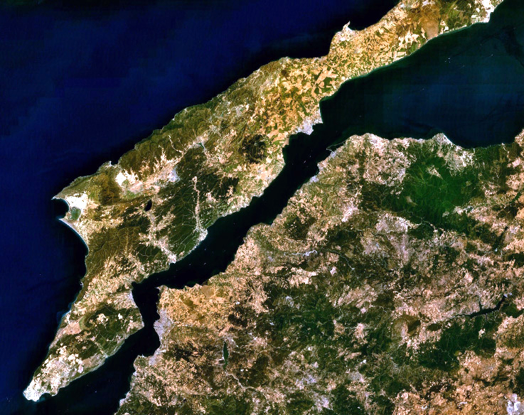
English: Landsat 7 image of the Dardanelles and Gallipoli Peninsula, Turkey. |
|||
| Date | ||||
| Source | Captured and cropped from NASA World Wind. | |||
| Author | NASA | |||
| Permission (Reusing this file) |
|

ཡིག་ཆའི་ལོ་རྒྱུས།
ཟླ་ཚེས་/དུས་ཚོད་གནུན་ཏེ་རྩོམ་ཡིག་ལ་ལྟ་བ།
| ཚེས་གྲངས། / དུས་ཚོད། | བསྡུས་དོན། | ཚད། | སྤྱོད་མི། | བསམ་ཚུལ། | |
|---|---|---|---|---|---|
| ད་ལྟ། | ༠༣:༠༦, ༢༦ ཟླ་དགུ་བ། ༢༠༡༣ | | ༧༣༧ × ༥༨༤ (༥༩༣ KB) | Jahoe | improved colour |
| ༡༢:༥༣, ༡༧ ཟླ་དགུ་བ། ༢༠༠༦ |  | ༧༣༧ × ༥༨༤ (༢༠༥ KB) | ChrisO | NASA Landsat 7 image of the Dardanelles and Gallipoli Peninsula, Turkey. Category:Satellite images of peninsulas |
ཡིག་ཆ་བེད་སྤྱོད་ཁུལ།
pagelinks འདི་ལ་སྦྲེལ་ཡོད།
Global file usage
The following other wikis use this file:
- Usage on af.wikipedia.org
- Usage on an.wikipedia.org
- Usage on ar.wikipedia.org
- Usage on arz.wikipedia.org
- Usage on ast.wikipedia.org
- Usage on azb.wikipedia.org
- Usage on be-tarask.wikipedia.org
- Usage on be.wikipedia.org
- Usage on bg.wikipedia.org
- Usage on ca.wikipedia.org
- Usage on ceb.wikipedia.org
- Usage on ckb.wikipedia.org
- Usage on co.wikipedia.org
- Usage on cs.wikipedia.org
- Usage on cy.wikipedia.org
- Usage on de.wikipedia.org
- Usage on el.wikipedia.org
- Usage on en.wikipedia.org
- Usage on eo.wikipedia.org
- Usage on eo.wikiquote.org
- Usage on es.wikipedia.org
- Usage on eu.wikipedia.org
- Usage on fa.wikipedia.org
- Usage on fr.wikipedia.org
- Usage on ga.wikipedia.org
- Usage on gl.wikipedia.org
- Usage on he.wikipedia.org
- Usage on ja.wikipedia.org
- Usage on kk.wikipedia.org
- Usage on ku.wikipedia.org
- Usage on ky.wikipedia.org
- Usage on lb.wikipedia.org
- Usage on nn.wikipedia.org
- Usage on no.wikipedia.org
- Usage on pl.wikipedia.org
- Usage on pl.wiktionary.org
View more global usage of this file.