
File:China Inner Mongolia.svg

Size of this PNG preview of this SVG file: ༧༠༥ × ༥༩༩ pixels. Other resolutions: ༢༨༢ × ༢༤༠ pixels | ༥༦༥ × ༤༨༠ pixels | ༩༠༤ × ༧༦༨ pixels | ༡,༢༠༥ × ༡,༠༢༤ pixels | ༢,༤༠༩ × ༢,༠༤༨ pixels | ༡,༠༠༠ × ༨༥༠ pixels.
ཐོག་མའི་ཡིག་ཆ། (SVG file, nominally ༡,༠༠༠ × ༨༥༠ pixels, file size: ༢༡༤ KB)
| Description |
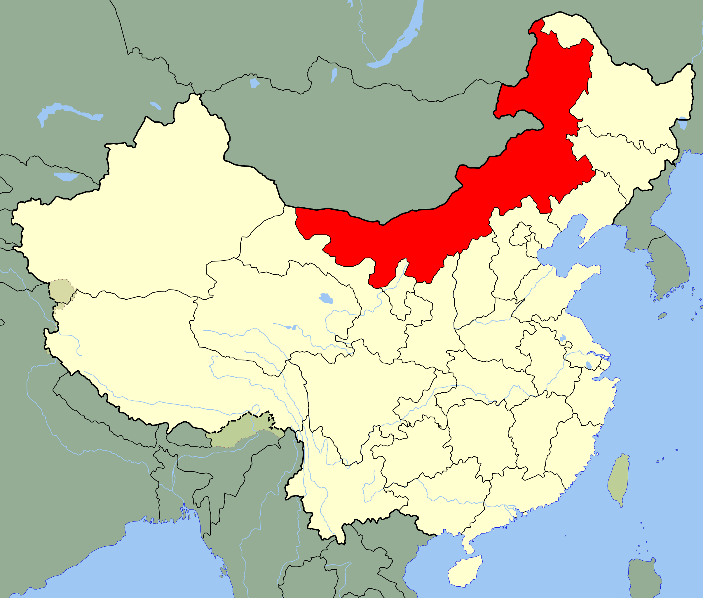
An SVG map of China with the Inner Mongolia autonomous region highlighted Legend: |
||
| Date | |||
| Source |
self-made; based on CIA public domain maps: |
||
| Author | Joowwww | ||
| Permission (Reusing this file) |
|
||
| Other versions |
|
ཡིག་ཆའི་ལོ་རྒྱུས།
ཟླ་ཚེས་/དུས་ཚོད་གནུན་ཏེ་རྩོམ་ཡིག་ལ་ལྟ་བ།
| ཚེས་གྲངས། / དུས་ཚོད། | བསྡུས་དོན། | ཚད། | སྤྱོད་མི། | བསམ་ཚུལ། | |
|---|---|---|---|---|---|
| ད་ལྟ། | ༡༦:༢༤, ༡༣ ཟླ་བརྒྱད་པ། ༢༠༠༨ | | ༡,༠༠༠ × ༨༥༠ (༢༡༤ KB) | Joowwww | added missing laos/vietnam border |
| ༡༡:༡༦, ༡༤ ཟླ་ལྔ་བ། ༢༠༠༨ |  | ༡,༠༠༠ × ༨༥༠ (༢༡༣ KB) | Joowwww | {{Information |Description=An SVG map of China with the Inner Mongolia autonomous region highlighted Legend:<br />Image:China map legend.png |Source=self-made; based on CIA public domain maps: *http://www.lib.utexas.edu/maps/middle_east_and_asia/chin |
ཡིག་ཆ་བེད་སྤྱོད་ཁུལ།
pagelinks འདི་ལ་སྦྲེལ་ཡོད།
Global file usage
The following other wikis use this file:
- Usage on ace.wikipedia.org
- Usage on ar.wikipedia.org
- Usage on br.wikipedia.org
- Usage on bs.wikipedia.org
- Usage on bxr.wikipedia.org
- Usage on cdo.wikipedia.org
- Usage on cs.wikipedia.org
- Usage on en.wikipedia.org
- Usage on eo.wikipedia.org
- Usage on es.wikipedia.org
- Usage on et.wikipedia.org
- Usage on eu.wikipedia.org
- Usage on fa.wikipedia.org
- Usage on fr.wikipedia.org
- Usage on fr.wikivoyage.org
- Usage on fr.wiktionary.org
View more global usage of this file.