
File:Argentina - Político 2.png

Size of this preview: ༣༦༣ × ༥༩༩ pixels. Other resolutions: ༡༤༥ × ༢༤༠ pixels | ༥༦༨ × ༩༣༧ pixels.
ཐོག་མའི་ཡིག་ཆ། (༥༦༨ × ༩༣༧ བརྙན་རྒྱུ།, ཡིག་ཆ་ཆེ་ཆུང།: ༢༥ KB, རྣམ་གཞག།: image/png)
བསྡུས་དོན།
| Description |
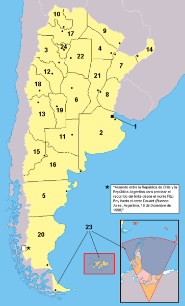
Español: Provincias de la Argentina. Los territorios en anaranjado no están bajo la soberanía argentina: se encuentran bajo la soberanía por el Reino Unido (ejemplo: Islas del Atlántico Sur) o es un reclamo en suspenso (ejemplo: Antártida)
English: Provinces of Argentina. Territories in orange are not under efective argentine soveregnity: they are either under british control, or in a suspended claim |
|||
| Date | ||||
| Source | Work based in the map at Image:Argentina - Político.png | |||
| Author | This map: Misionero and Gonzaloluengo. For the map this one is based over, check the link. | |||
| Other versions |
Derivative works of this file: Argentina.svg
|


Notas: 1: Ciudad de Buenos Aires (distrito federal)
2: Provincia de Buenos Aires
3: Catamarca
4: Chaco
5: Chubut
6: Córdoba
7: Corrientes
8: Entre Ríos
9: Formosa
10: Jujuy
11: La Pampa
12: La Rioja
13: Mendoza
14: Misiones
15: Neuquen
16: Rio Negro
17: Salta
18: San Juan
19: San Luis
20: Santa Cruz
21: Santa Fe
22: Santiago del Estero
23: Tierra del Fuego
24: Tucuman
གན་རྒྱ་ནང་ཞུགས་པ།
| I, the copyright holder of this work, release this work into the public domain. This applies worldwide. In some countries this may not be legally possible; if so: I grant anyone the right to use this work for any purpose, without any conditions, unless such conditions are required by law. |
ཡིག་ཆའི་ལོ་རྒྱུས།
ཟླ་ཚེས་/དུས་ཚོད་གནུན་ཏེ་རྩོམ་ཡིག་ལ་ལྟ་བ།
| ཚེས་གྲངས། / དུས་ཚོད། | བསྡུས་དོན། | ཚད། | སྤྱོད་མི། | བསམ་ཚུལ། | |
|---|---|---|---|---|---|
| ད་ལྟ། | ༡༨:༠༩, ༡༨ ཟླ་བཅུ་གཅིག་པ། ༢༠༡༧ | | ༥༦༨ × ༩༣༧ (༢༥ KB) | Janitoalevic | Better borders. |
| ༡༨:༠༦, ༡༨ ཟླ་བཅུ་གཅིག་པ། ༢༠༡༧ |  | ༥༦༨ × ༩༣༧ (༢༥ KB) | Janitoalevic | . | |
| ༡༧:༣༡, ༤ ཟླ་དགུ་བ། ༢༠༠༦ |  | ༥༦༨ × ༩༣༧ (༦༡ KB) | Gonzaloluengo | ||
| ༡༦:༥༦, ༢༣ ཟླ་བཞི་བ། ༢༠༠༦ |  | ༥༦༨ × ༩༣༧ (༣༩ KB) | Misionero~commonswiki | Mapa editado de: Argentina - Político.png {{es|Mapa de las provincias de la República Argentina. Los territorios en anaranjado no están bajo la soberanía argentina: se encuentran ocupados por Inglaterra (Ej:Islas del Atlántico Sur) o es un reclamo e |
ཡིག་ཆ་བེད་སྤྱོད་ཁུལ།
There are no pages that use this file.
Global file usage
The following other wikis use this file:
- Usage on en.wikipedia.org
- Usage on es.wikipedia.org