
File:Arch of Reunification.jpg
Size of this preview: ༨༠༠ × ༥༢༩ pixels. Other resolutions: ༣༢༠ × ༢༡༡ pixels | ༦༤༠ × ༤༢༣ pixels | ༡,༠༢༤ × ༦༧༧ pixels | ༡,༡༦༢ × ༧༦༨ pixels.
ཐོག་མའི་ཡིག་ཆ། (༡,༡༦༢ × ༧༦༨ བརྙན་རྒྱུ།, ཡིག་ཆ་ཆེ་ཆུང།: ༣༠༨ KB, རྣམ་གཞག།: image/jpeg)
| Description |
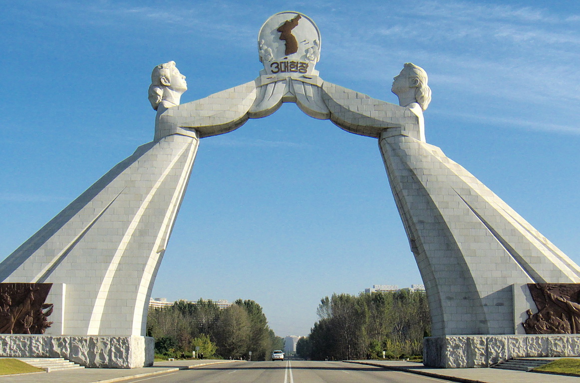
English: Featuring two Korean women in traditional garments reaching out to one another holding up a map of a unified Korea, the symbolism is obvious. Erected in 2001, the arch is sited rather aptly, on the Tongil expressway which leads straight to Panmunjom and eventually, Seoul. The three principles (formalized by Kim Il Sung during a meeting with the South in 1972) are independence, peaceful reunification and national unity. |
| Date | |
| Source | Crop of Monument to Three Charters for National Reunification, Pyongyang, North Korea |
| Author | Kok Leng Yeo from Singapore, Singapore |
| Camera location | | View this and other nearby images on: OpenStreetMap |
|---|
2024년 4월 27일 (토) 일정으로 저장됩니다.
གན་རྒྱ་ནང་ཞུགས་པ།
This file is licensed under the Creative Commons Attribution 2.0 Generic license.
- You are free:
- to share – to copy, distribute and transmit the work
- to remix – to adapt the work
- Under the following conditions:
- attribution – You must give appropriate credit, provide a link to the license, and indicate if changes were made. You may do so in any reasonable manner, but not in any way that suggests the licensor endorses you or your use.
| This image, originally posted to Flickr, was reviewed on 26 December 2008 by the administrator or reviewer MBisanz, who confirmed that it was available on Flickr under the stated license on that date. |
2024년 5월 3일 (금) 일정으로 저장됩니다.
ཡིག་ཆའི་ལོ་རྒྱུས།
ཟླ་ཚེས་/དུས་ཚོད་གནུན་ཏེ་རྩོམ་ཡིག་ལ་ལྟ་བ།
| ཚེས་གྲངས། / དུས་ཚོད། | བསྡུས་དོན། | ཚད། | སྤྱོད་མི། | བསམ་ཚུལ། | |
|---|---|---|---|---|---|
| ད་ལྟ། | ༡༧:༡༢, ༢༥ ཟླ་བཅུ་གཉིས་པ། ༢༠༠༨ | | ༡,༡༦༢ × ༧༦༨ (༣༠༨ KB) | Avala | {{Information |Description= Featuring two Korean women in traditional garments reaching out to one another holding up a map of a unified Korea, the symbolism is obvious. Erected in 2001, the arch is sited rather aptly, on the Tongil expressway which leads |
ཡིག་ཆ་བེད་སྤྱོད་ཁུལ།
pagelinks འདི་ལ་སྦྲེལ་ཡོད།
Global file usage
The following other wikis use this file:
- Usage on an.wikipedia.org
- Usage on ar.wikipedia.org
- Usage on ast.wikipedia.org
- Usage on bn.wikipedia.org
- Usage on ca.wikipedia.org
- Usage on ckb.wikipedia.org
- Usage on da.wikipedia.org
- Usage on de.wikipedia.org
- Usage on en.wikipedia.org
- Usage on es.wikipedia.org
- Usage on eu.wikipedia.org
- Usage on fa.wikipedia.org
- Usage on fi.wikipedia.org
- Usage on fy.wikipedia.org
- Usage on id.wikipedia.org
- Usage on it.wikipedia.org
- Usage on it.wikivoyage.org
- Usage on ja.wikipedia.org
- Usage on jv.wikipedia.org
- Usage on km.wikipedia.org
- Usage on kn.wikipedia.org
- Usage on ko.wikipedia.org
- Usage on mai.wikipedia.org
- Usage on mn.wikipedia.org
- Usage on nl.wikipedia.org
- Usage on pl.wikipedia.org
- Usage on pt.wikipedia.org
- Usage on ru.wikivoyage.org
- Usage on sv.wikipedia.org
- Usage on th.wikipedia.org
- Usage on uk.wikipedia.org
- Usage on zh.wikipedia.org