
File:Abraham Ortelius Map of Europe.jpg

Size of this preview: ༨༠༠ × ༥༨༤ pixels. Other resolutions: ༣༢༠ × ༢༣༤ pixels | ༦༤༠ × ༤༦༧ pixels | ༡,༠༢༤ × ༧༤༨ pixels | ༡,༢༨༠ × ༩༣༥ pixels | ༢,༦༩༡ × ༡,༩༦༥ pixels.
ཐོག་མའི་ཡིག་ཆ། (༢,༦༩༡ × ༡,༩༦༥ བརྙན་རྒྱུ།, ཡིག་ཆ་ཆེ་ཆུང།: ༥.༩༢ MB, རྣམ་གཞག།: image/jpeg)
བསྡུས་དོན།
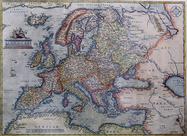
Hand-coloured copper engraving.
| Description | Map of Europe | |||||||||||||||||||||||
| Date | ༡༥༧༠ - ༡༦༠༩ | |||||||||||||||||||||||
| Source | Orteliusmaps.com | |||||||||||||||||||||||
| Author |
|
|||||||||||||||||||||||
| Other versions |
Donaldheat.com Orteliusmaps.com a Orteliusmaps.com b Orteliusmaps.com c Orteliusmaps.com d Orteliusmaps.com e |
|||||||||||||||||||||||

གན་རྒྱ་ནང་ཞུགས་པ།
|
This is a faithful photographic reproduction of a two-dimensional, public domain work of art. The work of art itself is in the public domain for the following reason:
The official position taken by the Wikimedia Foundation is that "faithful reproductions of two-dimensional public domain works of art are public domain".
This photographic reproduction is therefore also considered to be in the public domain in the United States. In other jurisdictions, re-use of this content may be restricted; see Reuse of PD-Art photographs for details. | ||||
ཡིག་ཆའི་ལོ་རྒྱུས།
ཟླ་ཚེས་/དུས་ཚོད་གནུན་ཏེ་རྩོམ་ཡིག་ལ་ལྟ་བ།
| ཚེས་གྲངས། / དུས་ཚོད། | བསྡུས་དོན། | ཚད། | སྤྱོད་མི། | བསམ་ཚུལ། | |
|---|---|---|---|---|---|
| ད་ལྟ། | ༠༠:༣༨, ༡༢ ཟླ་བརྒྱད་པ། ༢༠༢༡ | | ༢,༦༩༡ × ༡,༩༦༥ (༥.༩༢ MB) | RafalZero7 | Cropped 2 % horizontally, 3 % vertically using CropTool with precise mode. |
| ༠༩:༡༧, ༡ ཟླ་བཞི་བ། ༢༠༡༡ |  | ༢,༧༤༩ × ༢,༠༡༧ (༥.༥༡ MB) | Joop Rotte | {{Information |Description= |Source= |Date= |Author= |Permission= |other_versions= }}http://www.orteliusmaps.com/highresolution/6092_96.htm | |
| ༡༠:༣༤, ༢༤ ཟླ་དང་པོ། ༢༠༠༦ |  | ༦༢༩ × ༤༦༨ (༢༨༧ KB) | AndreasPraefcke | Abraham Ortelius: Map of Europe, 1595 Hand-coloured copper engraving. {{Creator:Abraham Ortelius}} {{PD-art}} Source: http://www.donaldheald.com/ Category:Maps of Europe |
ཡིག་ཆ་བེད་སྤྱོད་ཁུལ།
pagelinks འདི་ལ་སྦྲེལ་ཡོད།
Global file usage
The following other wikis use this file:
- Usage on ar.wikipedia.org
- Usage on azb.wikipedia.org
- Usage on az.wikipedia.org
- Usage on ba.wikipedia.org
- Usage on be-tarask.wikipedia.org
- Usage on be.wikipedia.org
- Usage on bn.wikipedia.org
- Usage on bs.wikipedia.org
- Usage on ceb.wikipedia.org
- Usage on cs.wikipedia.org
- Usage on da.wikipedia.org
- Usage on el.wikipedia.org
- Usage on en.wikipedia.org
- Usage on es.wikipedia.org
- Usage on fa.wikipedia.org
- Usage on fr.wikipedia.org
- Usage on fy.wikipedia.org
- Usage on ga.wikipedia.org
- Usage on ha.wikipedia.org
- Usage on hr.wikipedia.org
- Usage on hy.wikipedia.org
- Usage on id.wikipedia.org
- Usage on it.wikipedia.org
- Usage on ko.wikipedia.org
- Usage on la.wikipedia.org
- Usage on lv.wikipedia.org
- Usage on mk.wikipedia.org
View more global usage of this file.